Easing swell ahead of a new pulse Friday and then average weekend

Western Australia Surf Forecast by Craig Brokensha (issued Wednesday 1st June)
Best Days:
Recap
Firstly, sad to hear about the attack to Ben Gerring down around Mandurah yesterday, thoughts to him and his family/friends. We saw a large and powerful W/SW groundswell building across all regions through the day, from the 8ft range in the South West and 2ft further north.
Conditions remained favourable most of the day across all locations as the swell continued to kick. A peak was seen overnight with easing clean and pumping waves from 8-10ft in the South West, 3ft around Mandurah and Perth.
This week and weekend (Jun 2 - 5)
Our recent large large W/SW groundswell will continue to ease through this evening, backing off from the 6-8ft range in the South West tomorrow, 2-3ft still around Perth further into the afternoon.
Conditions will be OK early with a fresh E/NE offshore, but this is due to tend more NE through the day in the South West.
Our new W/SW groundswell for Friday is still on track, with the strong frontal progression firing up north of Heard Island the last couple of days. This swell should build throug the day and reach 6-8ft across the South West and 2ft+ in Perth. Winds look average though with a fresh N/NE tending NW breeze.
Into the weekend the swell will ease but gusty onshore SW tending S/SW winds will continue to create average conditions.
Sunday looks cleaner around Perth but there'll only be tiny leftovers, while Margs looks to see NW breezes.
Next week onwards (Jun 6 onwards)
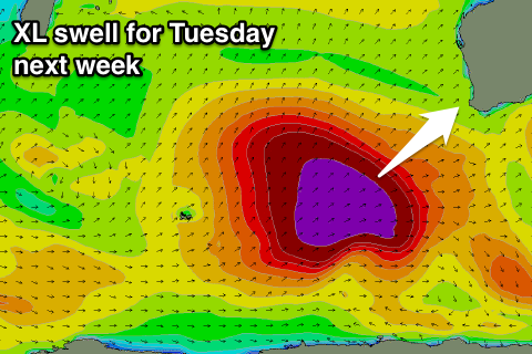 Monday will remain small and average with freshening N/NW winds, but heading into the evening and more so Tuesday, a large and powerful long-period SW groundswell is due.
This will be generated by a vigorous polar low firing up under a strong and broad node of the Long Wave Trough, with a vigorous polar low developing west of Heard Island expected to produce a fetch of severe-gale to storm-force SW winds before projecting towards us while weakening but broadening over the weekend.
An XL swell should be generated, building later Monday and peaking Tuesday to 12-15ft across the South West, larger at offshore bommies, and 3-4ft in Perth. Conditions are looking a little average with strong S/SE winds, but we'll review this Friday.