Large swell with great winds

Western Australia Surf Forecast by Craig Brokensha (issued Monday 30th May)
Best Days: Tuesday, Wednesday, Thursday
Recap
Average onshore choppy waves Saturday with a building swell which peaked Sunday to a strong 3-4ft around Perth and 10ft in the South West with the cleanest conditions to the north with a light E'ly (SE around Margs).
This morning the surf was much cleaner in the South West and easing back from 4-6ft with 2ft waves around Perth.
This week (May 31 – Jun 5)
As Ben mentioned a couple of weeks ago when he took over, it's a little tricky coming in cold to a forecast, but I'll pick up where he left off.
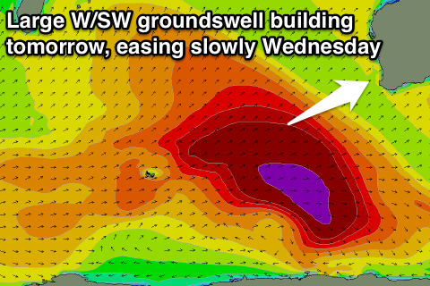
 Our current W/SW groundswell is expected to continue to ease into this evening but from tomorrow morning, a strong new long-period and large W/SW groundswell is due to build rapidly and reach a peak into the late afternoon/evening.
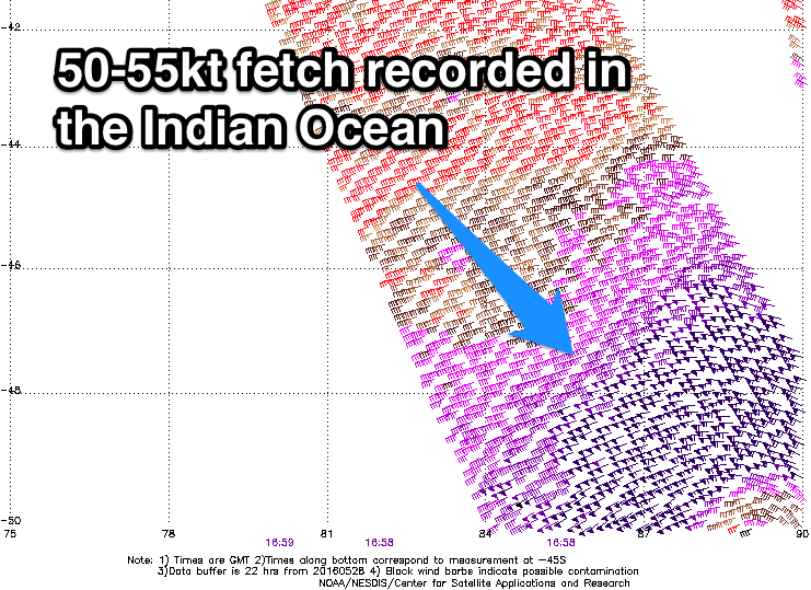
This swell was generated by a very broad and vigorous polar frontal progression through the southern Indian Ocean the last few days, with satellite observations picking up a healthy fetch of 50-55kt W/SW winds.
A large long-period W/SW groundswell has resulted and there's no real changes to Ben's figures with exposed breaks in the South West due to reach an easy 10-12ft late, with 15ft+ sets at offshore bommies, and Perth should kick to 3-4ft late.
 A touch less size is due Wednesday morning with the swell easing slowly through the day, further from Thursday but slowed by a reinforcing W/SW groundswell pulse from trailing fetches of W'ly gales on the backside of the progression.
The South West should still be offering 8ft sets, easing through the day and then 2-3ft in Perth.
Conditions tomorrow should be clean early with a light E/NE offshore tending NE through the morning and then variable through the afternoon across the South West, S/SW in Perth.
Wednesday then looks excellent with a light to moderate offshore E'ly breeze, tending variable from the SE through the afternoon. Fresher NE winds will then develop Thursday and likely tend to a better E/NE'ly mid-late afternoon.
Into the end of the week a new moderate to large sized W/SW groundswell is expected as another strengthening polar front generates a pre-frontal W/NW and then post-frontal W/SW fetch of gales.
This swell is due to build through Friday and reach 6-8ft in the South West and 2ft+ in Perth but with poor and strengthening N/NE winds.
This will be ahead of a fresh SW tending W/SW change Saturday creating poor conditions.
This looks to be the start of a run of poor onshore winds through early to mid next week, but have a check back here Wednesday for more on this.
In the meantime make the most of the coming swells and favourable winds but surf within your ability.
Comments
Looking pretty tidy on the Perth metro beaches this arvo.
Solid in Margs..
Impressive swell that one !