Plenty of swell for the South West but with persistent onshore winds

Western Australia Surf Forecast by Craig Brokensha (issued Wednesday 4th May)
Best Days: Perth tomorrow and Sunday morning, protected spots in the South West Sunday morning
Recap
A large and powerful S/SW groundswell filled in yesterday across the coast but conditions were poor across the South West with a moderate to fresh S/SW wind while cleaner conditions were seen around Perth as the swell kicked through the day.
This morning the swell was holding a fun and clean 2-3ft around Perth, while Mandurah was smaller and around 2ft, with easing 8ft sets in the South West.
This week and weekend (May 5 – 8)
A slight bump in swell from a less than favourably aligned front is due into tomorrow, but this is only likely to keep 6ft sets hitting the South West, with small 1-2ft waves around Perth.
Conditions will remain average as well with a moderate to fresh S/SW'ly across the South West but cleaner waves around Perth with a SE'ly.
This swell is then due to ease into Friday as freshening W/NW winds create even worse conditions.
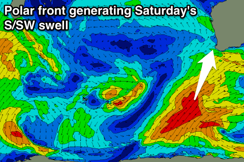 A new S/SW groundswell is due into Saturday from a relatively weak polar front projecting up towards us from the polar shelf, but this will be mixed in with some SW windswell as a tight mid-latitude low pushes in from the west and across us.
A mix of swells are due coming in at 6ft across the South West, while Perth should build to a stormy 2ft to likely 3ft through the afternoon. Strong S/SW winds will create poor conditions as well.
Cleaner waves are due into Sunday in the wake of the mid-latitude low, with light S/SE winds across the South West and SE breezes up in Perth and the swell will ease back from 4-5ft and 2ft respectively.
Next week onwards (May 9 onwards)
The surf is due to bottom out into Monday and lingering onshore SW winds will continue to create poor conditions in the South West.
A couple of moderate pulses of SW groundswell are due Tuesday afternoon and then Wednesday and Thursday from a flurry of strong but less than favourably aligned and short-lived frontal activity north of the Heard Island region.
We're looking at pulses to 5-6ft or so across the South West and 1-2ft in Perth but clean conditions look to evade Margs as fronts continue to ride high in latitude.
Longer term some larger swell is on the way for the next weekend, but check back here Friday for more on this.