Good Friday and Saturday, average thereafter

Western Australia Surf Forecast by Craig Brokensha (issued Wednesday 13th April)
Best Days: Friday and Saturday in the South West, Friday and Saturday afternoon around Perth
Recap
Nothing of note the last couple of days with onshore winds and small amounts of swell.
This week and weekend (Apr 14 - 17)
Into the end of the week we've got a mix of short-range SW swell and long-range and inconsistent W/SW groundswell due.
The long-range W/SW groundswell has been discussed the last few updates and should kick later tomorrow to 3-5ft, peaking Friday morning around a very inconsistent 4-6ft across the exposed reefs in the South West. Perth should offer 1ft to occasionally 2ft sets.
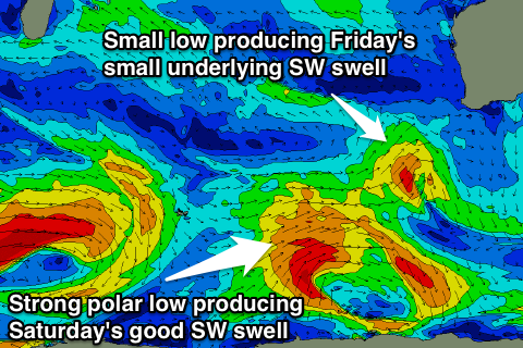 Also in the mix Friday morning will be a small mid-period SW swell from a small and weak mid-latitude low that's currently south-west of us. This should provide 3-4ft sets in between the longer-range energy.
Now conditions tomorrow will be average with a lingering and increasing onshore W/SW tending SW breeze, but come Friday a ridge of high pressure sliding in from the west will see conditions improve through the day with a moderate to fresh SE tending E/SE breeze as the swell starts to ease.
This will be the day we'll likely see competition resume for the Margaret River Pro.
Early Saturday morning will be a temporary low point in activity before a better more consistent SW swell builds through the mid-morning peaking into the afternoon.
This is being generated by not an overly strong, but persistent polar low moving from the Heard Island, east with a fetch of W/SW gales being produced through our south-western swell window.
Exposed breaks around Margs should kick back to 4-6ft through the day, with Perth seeing maybe 1-2ft sets into the mid-late afternoon.
Conditions should be clean with a fresh E/NE offshore, tending more NE through the morning while easing and tending variable into the afternoon (a good finals day for the Margaret River Pro).
Sunday will then be average with an easing swell and onshore W/NW tending NW breeze.
Next week onwards (Apr 18 onwards)
Monday looks to be another lay day with a fresh to strong onshore W/NW to SW wind associated with a small mid-latitude low moving into us.
This will kick up a short-range SW windswell through the afternoon, fading Tuesday.
As the short-range SW swell fades, a better long-range SW groundswell is due to fill in, produced by a strong and elongated fetch of severe-gale W'ly winds south-west of Heard Island, weakening once pushing east past it.
Good sets in the 5-6ft+ range are due Tuesday with 1-2ft waves in Perth through the day, but winds look a little dicey and from the S/SE to S/SW. We'll have a closer look at this Friday.