Pumping Saturday, easing through Sunday

Western Australia Surf Forecast by Craig Brokensha (issued Friday 1st April)
Best Days: Saturday, Sunday morning, Wednesday morning
Recap
Onshore winds and a kick in swell yesterday, while today the larger SW groundswell is on the build, but with fresher onshore winds across all coasts. This swell should reach an easy 6-8ft across the South West this afternoon, with 10ft bombs, and 2ft around Perth, with winds swinging S/SE late in the South West, creating cleaner conditions in protected spots.
This weekend (Apr 2 - 3)
Today's large SW groundswell was generated by a broad, vigorous and elongated polar front projecting up towards us the last day or so.
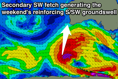 This swell will peak this afternoon, but a secondary intensification through our southern swell window is occurring today, with an additional fetch of severe-gale SW winds projecting more towards the Bight.
This should produce a reinforcing S/SW groundswell for later tomorrow and Sunday morning, slowing the easing trend through the weekend.
The South West should ease from 6-8ft+ early tomorrow, down from 5-6ft Sunday morning. Perth should ease from 2ft tomorrow, and then 1ft to possibly 2ft Sunday morning.
Conditions are still looking excellent tomorrow and better for Sunday with a light offshore E/SE breeze tomorrow morning ahead of afternoon sea breezes, with SE tending E/SE winds Sunday morning before sea breezes kick in.
Next week onwards (Apr 4 onwards)
The surf should bottom out Monday but still be in the 3-4ft range across the South West, but conditions will be average with a freshening onshore wind.
This onshore change will be linked to a small low pushing up towards us through the weekend, kicking up a weak short-range S/SW swell, building Tuesday and then easing Wednesday.
The South West should build to 4-5ft, easing then from 3-4ft+ Wednesday morning. S/SE winds are due Tuesday which isn't the best combo with the building S/SW swell, and then Wednesday looks better with a gusty E'ly offshore.
Longer term besides some small refracted SW groundswell for later next week, there's nothing major on the cards, but we'll have another look at this Monday. Have a great weekend!
Comments
Yeah! Finally .....
Reckon they'll run Margs this weekend? Long range looks pretty average.
Outlook is very average, no major swells at all with a large blocking high.
Probably biggest Fri/Sat around 3-5ft with a S/SW swell, then around the 3-4ft range for the rest of the comp. A couple of smaller days and then a couple of bigger as well but nothing of significance.
Perfect forecast for the brazzos to shine!!!