Clean easing weekend, new S/SW swells next week, best Wednesday

Western Australia Surf Forecast by Craig Brokensha (issued Friday 18th March)
Best Days: Saturday morning, Wednesday morning, Thursday morning, Friday morning
Recap
Average conditions yesterday with a bumpy 3-4ft of swell across the South West and tiny waves to the north.
Today a better S/SW groundswell has filled in with good sets across exposed breaks under stiff offshore E/SE-SE winds. Perth and Mandurah remained tiny due to the S'ly swell direction.
This weekend (Mar 19 - 20)
Today's pulse of S/SW groundswell across the South West will fade back over the weekend with weaker offshore winds. A drop from 3-4ft+ is expected across exposed breaks tomorrow morning with moderate to fresh offshore E/SE winds, tending S/SE through the day.
Sunday will be smaller with SE winds, and not too special.
Next week onwards (Mar 21 onwards)
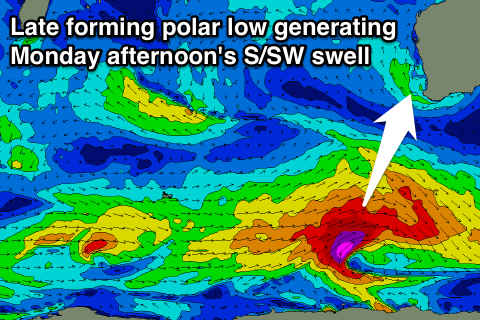
Monday afternoon/Tuesday's S/SW groundswell event is now looking better with the vigorous polar low generating it forming a little earlier in our swell window. We'll see a fetch of storm-force W/SW winds generated in our southern swell window, with the groundswell arriving through Monday, building to a peak around 4-6ft later in the day.
 Tuesday morning should be around the same size, but a new short-range S/SW swell will take its place, generated by a cold front pushing right up and into us through Sunday and Monday.
This swell should peak through Tuesday around 4-6ft, easing back slowly from 4-5ft Wednesday morning.
Perth isn't due to see any of the S/SW groundswell, but the short-range S/SW should offer 1-2ft sets into the afternoon Tuesday, fading from 1-1.5ft Wednesday.
Conditions Monday will be less than ideal with an early S/SE tending S/SW breeze, with fresh S/SE winds on Tuesday.
Wednesday is the pick with an E/SE offshore, becoming strong from the S/SE into the afternoon.
Easing surf with offshores is due into Thursday with a low point in swell Friday morning.
Longer term another dose of S/SW groundswell is due Friday and Saturday from a late forming polar frontal system in our swell window, but more on this Monday. Have a great weekend!