Easing surf with decent winds tomorrow, average until Saturday morning

Western Australia Surf Forecast by Craig Brokensha (issued Monday 15th February)
Best Days: Tuesday morning swell magnets around Margs, Saturday morning in the South West
Recap
An average bumpy start to the weekend with small surf with S'ly winds, while Sunday saw the arrival of a good new SW groundswell to 3-5ft with offshore winds. Perth and Mandurah saw a tiny kick in size but nothing too substantial.
Today the SW swell was down a touch but still kicking around 3-5ft across the South West with improving winds through the day, while to the north we were back to tiny offerings.
This week and weekend (Feb 16 - 21)
Today's swell should ease back through tomorrow and further into Wednesday morning, but winds will be good for exposed breaks tomorrow morning. A slightly weaker but favourable and fresh E/NE breeze is due, tending variable into the afternoon ahead of late S/SE winds or a sea breeze.
Wednesday is now looking dicey with a dawn E/SE'ly due to give way to a S'ly change through the day.
A very slight increase in new SW groundswell is due Thursday with a better pulse Friday from a couple of weak post-frontal fetches of W/SW winds.
A slight kick to a small 3ft range across swell magnets is due Thursday, with slightly more size Friday to 3-4ft. Perth and Mandurah aren't expected to see any real size with tiny 0.5-1ft sets.
Winds will swing more SE into Friday but with strength, creating poor conditions.
 Saturday will be better with offshore E/SE winds and easing 3ft sets across swell magnets, smaller into Sunday morning as S'ly winds kick back in again.
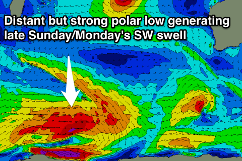
Longer term we've got an inconsistent long-period SW groundswell on the cards for later Sunday and Monday, generated by a strong but distant and short-lived polar low forming south-west of Heard Island.
Due to the large distance between the source of the swell and our coasts we'll see a fair bit of swell decay and loss of consistency with infrequent 3-5ft sets due very late Sunday, with holding Monday morning with a better kick later in the day to 4-5ft with a touch more consistency.
Winds look less than ideal and from the S/SE, but more on this Wednesday.
One final note, and Tropical Cyclone Uriah which is currently just west-southwest of the Cocos Islands will meander through the central Indian Ocean throughout the whole forecast period, but with no significant NW fetch aimed towards us, along with its solitary nature, we're not expected to see any significant swell from the system. A slight W/NW groundswell signal may be seen early next week when Uriah drifts slightly south-east through our swell window, but we'll have another look at this Wednesday.
Comments
Craig any chance we will see any nw swell from TC Uriah?
Ah sorry, should of made note of it, no unfortunately, it's a solitary distant system with no real favourable NW fetch aimed towards WA.
It's producing swell heading more towatds Africa and Madigascar. If we do see any swell it will be from Sunday through Wednesday next week as it veers slightly back to the south-east. In saying this maybe 2-3ft max in Margs, tiny around Perth.