Poor outlook, best later next week

Western Australia Surf Forecast by Craig Brokensha (issued Friday 22nd January)
Best Days: Thursday morning, Friday morning, next Saturday morning
Recap
Wednesday's building mix of swells eased back quicker than anticipated into yesterday morning, but average SE-S/SE winds created average conditions.
Today the surf was cleaner but much smaller with 2-3ft sets across swell magnets, tiny to the north.
This weekend and next week (Jan 23 – 29)
Unfortunately the forecast period ahead isn't too exciting at all with small to tiny amounts of swell over the weekend with SE-E/SE winds tomorrow and then SE wind Sunday morning.
A very slight kick in mid-period SW swell is due Monday but to 3ft max across the South West as morning SE winds continue.
Tuesday and Wednesday are due to be smaller with even less favourable S/SE winds.
The reason for these poor winds and lack of swell is a large blocking high setting up camp to our west, deflecting any major swell generating systems away from us while also directing south-east winds across the state.
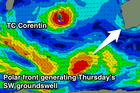 A small to moderate sized SW groundswell is due Thursday, generated by a strong polar frontal system skirting around the blocking high, filling in through the day and offering 4-5ft sets across exposed breaks around Margs, kicking to 1ft+ through the afternoon in Perth.
Winds should swing more E/SE but will be strong for this swell, tending more S/SE into the afternoon.
A slow easing trend is then due through Friday and Saturday from secondary less favourably aligned polar frontal activity, with better E/NE winds.
Also worth noting is that Tropical Cyclone Corentin in the central Indian Ocean will have no influence on our coast at this stage.
Longer term there's still nothing too major on the cards, but have a check back here on Monday for another update. Have a great weekend!