Best tomorrow morning across the South West, but windy

Western Australia Surf Forecast by Craig Brokensha (issued Wednesday 13th January)
Best Days: Exposed breaks in the South West tomorrow morning and swell magnets Friday and Saturday mornings
Recap
Average onshore waves yesterday across most locations, while today a strong new SW groundswell has filled in across the South West to 6-8ft at exposed breaks, smaller in protected spots but cleaner with SE winds. Mandurah saw fun 2ft sets, with clean 1-2ft waves up in Perth.
This week and weekend (Jan 14 – 17)
Today's SW groundswell was generated by a tight mid-latitude low forming to our south-west, with it moving east through the Bight and out of our swell window Tuesday morning.
A swing in direction and quick drop in size from the S/SW is expected tomorrow but with better offshore but strong E/NE winds across most locations with sea breezes in the South West (remaining offshore across Perth). Late morning to midday will be the pick as winds ease ahead of the sea breeze.
Margs should ease from 3-4ft across south swell magnets with tiny 1ft waves around Perth.
Friday will be clean again under E/NE offshores but the surf small to tiny even in the South West and only workable at swell magnets.
A fun small pulse of new SW groundswell is due Saturday across the South West from a small tight low generating a burst of W/SW gales while drifting unfavourably south-east.
A small kick to 3-4ft is expected across exposed breaks into the afternoon, easing back a touch Sunday morning, ahead of a secondary slightly stronger kick more to 3-5ft later Sunday and early Monday. Perth isn't due to see any size Saturday, with Monday offering 1ft sets max.
Conditions will be clean Saturday morning with E/NE offshores, tending variable ahead of a late S/SW change, with strong and poor S'ly winds Sunday.
Next week onwards (Jan 18 onwards)
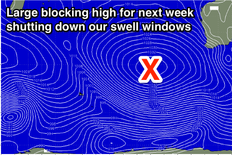 Fresh to strong S/SE winds are expected to persist into Monday across all locations as a strong high-pressure ridge moving in from the west squeezes against a mid-latitude low sitting off our South Coast.
Protected locations will fair best in the South West but offer very limited sized.
Smaller waves and a relaxation in S/SE winds will continue to limit options.
The strong high-pressure ridge moving in from the west next week will block our major swell windows, resulting in small waves continuing for the rest of next week, bottoming out into the following weekend and beyond. We'll have a closer look at this Friday though.
Comments
Coupla nice waves around the Margs region. But Cape Nat is gusting 36kts out of the east, and Leeuwin's gusting 30kts (was up to 39kts overnight). Interestingly, doesn't look quite this windy at Margs right now.