Nothing special, with windows of OK waves

Western Australia Surf Forecast by Craig Brokensha (issued Wednesday 25th November)
Best Days: No great days, south swell magnets Friday morning in the South West, Wednesday morning in the South West
Recap
Poor waves in general with small to tiny amounts of swell and S/SE winds leaving no decent surfing options.
This week and weekend (Nov 26 - 29)
Our acute pulse of S'ly swell due tomorrow across the South West is still on track, with a polar front developing to our south-southwest and projecting up towards SA.
 We should see exposed breaks to the south swell kicking to 4-5ft through the day, easing quickly from 3ft+ or so Friday morning. Perth will fail to pick up any size due to the southerly swell direction.
Conditions tomorrow look good with offshore E/SE winds ahead of sea breezes, and then Friday looks a little dicey with morning SE breezes.
Saturday isn't expected to see any decent swell and with morning SE winds.
Sunday morning will start real slow, but an inconsistent and small pulse of SW swell is due into the afternoon from a small weak and unfavourably tracking low through our swell window today and tomorrow. A small kick to 3ft+ is expected later in the day but with poor and strong S'ly winds. Perth will remain tiny.
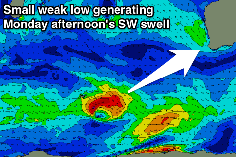
A better pulse for Monday afternoon from a stronger secondary low should see better 3-5ft waves, 1ft in Perth but along with strong S/SE winds.
The swell should drop through Tuesday with better E/SE winds but not much size. A new S/SW swell is due into the afternoon from a weak front pushing up towards our South Coast early next week, but again only to 3-5ft across south swell magnets, easing from a similar size Wednesday morning. Perth will struggle to top 1ft.
Longer term, small pulses of swell are due to continue as the storm track remains focussed away from us and without any potency, but check back here Friday for any change to this.