Good waves on offer from Friday

Western Australia Surf Forecast by Craig Brokensha (issued Wednesday 18th November)
Best Days: Protected spots in the South West tomorrow afternoon, Friday morning, later Sunday in the South West, Sunday morning, Monday morning
Recap
We saw a small window of offshores yesterday morning across the South West, but the swell was missing with smaller than expected 3ft waves across the coast. Onshores quickly moved in, with a building windswell which has come in at a solid 6ft+ across the South West and 2-3ft around Mandurah and 2ft in Perth.
A further increase will be seen through the day as the low continues to slowly move across us, but conditions will remain poor.
This week and weekend (Nov 19 - 22)
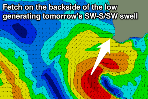 The strong and slow moving mid-latitude low currently influencing the southern half of the state is producing a healthy fetch of gale to near severe-gale S/SW winds on its western flank, and this should produce a large SW tending S/SW groundswell for tomorrow across the South West.
Perth will see good levels of W/SW swell persisting from today, with easing S/SW swell Friday.
Exposed locations in the South West are due to come in around the 6-8ft+ range through most of tomorrow, backing off quickly from 6ft or so Friday morning.
Perth should see 2-3ft sets tomorrow, easing quickly from 2ft on the sets Friday morning.
Now, conditions tomorrow will remain poor with SW tending S/SW winds, likely tending back to the S'th on dark in the South West, favouring protected spots.
Friday will be much cleaner with E/SE offshores across all locations, tending variable around Perth, and with S/SE winds likely into the afternoon around Margs.
Saturday morning will be small to tiny but clean with E/NE offshores, while a new pulse of SW groundswell due into the afternoon has been delayed a little and is only due to arrive real late in the day across the South West.
The vigorous but unfavourably aligned polar frontal progression generating this swell is currently producing gale to severe-gale W/NW winds in the Heard Island region.
The front will continue tracking east before moving out of our swell window Friday morning.
An inconsistent but good SW groundswell will spread up radially towards us, kicking late in the day Saturday to 5-6ft by dark across the South West, easing Sunday morning from the 5-6ft+ range. Perth is only likely to see very infrequent 1-2ft sets Sunday.
Winds will be favourable for selected spots late Saturday in the South West and likely from the SE, with Sunday seeing morning E/NE offshores, tending NW through the day.
Next week onwards (Nov 23 onwards)
Fading levels of SW swell and variable winds are due Monday but for the rest of the week there's nothing significant at all on the cards unfortunately. A small weak W/SW swell is likely late week with a small S/SW groundswell also, but we'll have another look at this on Friday.
In the meantime plan around the favourable conditions Friday and over the weekend.