Good week ahead with a strong SW swell Thursday with decent winds

Western Australia Surf Forecast by Craig Brokensha (issued Monday 9th November)
Best Days: Every day over the coming period besides Wednesday and Sunday
Recap
Not the best weekend of waves, with limiting S'ly winds Saturday and an easing swell, while Sunday saw a strong new building SW groundswell pulse but again protected spots were the pick with only a short period of favourable offshores during the morning.
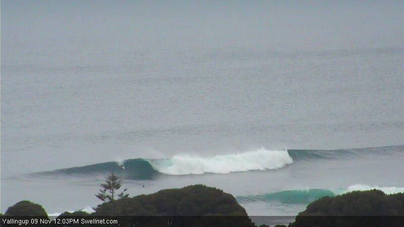
Today the SW groundswell pulse was easing as a more consistent and better SW groundswell was on the build with S/SE tending SE winds. This left protected locations with the best conditions again, but more exposed spots have improved this afternoon (right) across the South West with the more east in the wind. Perth has remained less than ideal though with average onshore waves but the swell has kicked a bit.
This week (Nov 10 - 13)
A good pulse of reinforcing SW groundswell due this afternoon to 6ft to occasionally 8ft in the South West across exposed breaks and 2ft+ in Perth is due to ease back through tomorrow slowly from the 6ft+ and 2ft range respectively.
Conditions are looking great with offshore E/NE winds across both regions, tending variable through the middle of the day ahead of afternoon sea breezes.
Wednesday is looking dicey as the swell bottoms out with S/SE breezes leaving protected locations with the only decent waves.
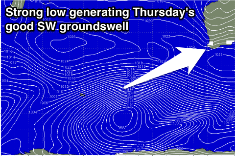 Thursday afternoon's large kick in SW groundswell is still on track, with a vigorous polar low forming in the Heard Island region this morning. A broad fetch of gale to sub-severe-gale W/SW winds will be projected towards us, this evening and tomorrow before the front starts to weaken and push east out of our swell window on Wednesday afternoon.
The swell should build strongly through the day Thursday from 4-5ft through the morning to a strong 6-8ft+ across exposed breaks into the afternoon, with 2ft to occasionally 3ft in Perth through the mid-late afternoon.
Now, winds on Thursday morning look good around Perth and from the E/SE, but Margs will likely see winds holding fresh and gusty from the SE, possibly flirting with the E/SE at times before strengthening from the S/SE into the afternoon as the swell really kicks. Perth is more than likely to see a strong S/SW sea breezes.
Come Friday better E/SE offshores are due around the South West with E'ly tending E/NE winds around Perth ahead of sea breezes. The swell should ease back gradually from 6ft+ and 2ft+ respectively.
This weekend onwards (Nov 14 onwards)
Saturday's the pick of the weekend with offshore winds again and easing levels of leftover SW swell from 4-5ft or so around Margs and 1ft to maybe 2ft in Perth. Sunday then looks average with smaller surf and S/SE winds.
Longer term there's nothing significant at all on the cards with a blocking setup establishing to our west after this week's activity. This may break down into the middle of next week in the form of a mid-latitude low moving in from the west, but we'll review this Wednesday.