Windows of clean workable waves, nothing epic

Western Australia Surf Forecast by Craig Brokensha (issued Friday 9th October)
Best Days: Saturday morning Perth, Sunday and Monday mornings swell magnets, Wednesday exposed breaks
Recap
Not the best combo of swell and winds yesterday with S/SE breezes across the South West (lighter around Perth) and a smaller swell.
Today conditions were a little better as winds tended SE with 3-5ft sets in the South West and 1-2ft waves up around Perth. Sea breezes are now in, but our late kick in stronger SW groundswell is still on track for the South West, with exposed breaks due to reach 5-6ft.
This weekend and next week (Aug 10 - 16)
This evening's late kick in long-range and inconsistent SW groundswell should ease back from a very infrequent 4-5ft across the South West tomorrow, with 1-2ft sets up around Perth through the morning, smaller into the afternoon.
Winds will again swing back to a less than favourable S/SE'ly across the South West, but Perth should see lighter E/NE winds through the morning before the change and S/SW breeze arrive together late morning.
Sunday should see inconsistent and easing 3-5ft waves in the South West and 1-1.5ft up around Perth with E/SE offshores, stronger in the South West.
 You'll want to hit up swell magnets around Margs into Monday as the swell continues to wane but with good winds, moderate from the E/SE (possibly tending E/NE through the morning).
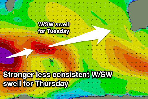
A small uptick in size is Tuesday as some small to moderate sized W/SW groundswell arrives from a broad pre-frontal fetch of W/NW gales in the south-west Indian Ocean, ahead of the broader and slow moving polar low linked to Thursday's W/SW groundswell.
A very inconsistent but fun 4-5ft+ wave should be seen through Tuesday across the South West, with 1-1.5ft waves up in Perth. Wednesday should be around the same size, if not a touch smaller, with the longer-range long-period W/SW groundswell filling in for Thursday.
The wait between sets for this swell will be quite considerable, but when they come we should see strong 6-8ft waves across the exposed reefs in the South West, with the chance of the odd bigger cleanup set, with infrequent 2ft waves across Perth.
Winds look to go dicey from the S'th Tuesday with offshores from the E/SE Wednesday, but Thursday as the swell peaks, onshore SW winds look to be the spoiler in the wake of a change Wednesday afternoon.
Longer term we may see some stronger polar frontal activity to our south west later next week, producing some better groundswell from the weekend onwards, but more on this Monday. Have a great weekend!
Comments
Still some bombs at Southside.