Sunday is looking bigger than previous anticipated

West Australian Surf Forecast by Guy Dixon (issued Wednesday 2nd September)
Best Days: Thursday, Sunday, Monday, Tuesday morning
Recap:
A fresh southerly breeze limited options to only the most protected spots along the South West on Tuesday. We had a strong 6ft+ swell in the water, which faded back to around 5-6ft by dark, however the winds were making for turbulent and chopped up conditions at the more exposed spots. Perth and Mandurah offered peaky 2-3ft short range surf under a fresh southerly winds with little to no quality or structure.
Today brought cleaner conditions under a light offshore flow. The surf has faded significantly with easing 3-5ft swell across the South West this morning and 1-2ft for Perth and Mandurah.
This week (Thursday 3rd - Friday 4th):
Thursday will see a fresh southwesterly groundswell impact the South West generated by a westerly fetch which produced 50kt gusts east of Heard Island yesterday. The surf is likely to build throughout the afternoon to around 6ft with a few 8ft sets late. As for Perth and Mandurah, the system responsible was/is located too far south to generate any decent size, so the surf will only bump up to the 1-2ft range.
Winds look good right along the coast, particularly in the morning. The South West will be under a light/moderate east/northeasterly breeze early, tending northeasterly and easing in the afternoon. Metro beaches are also looking at easterly breezes, tending east/northeasterly in the afternoon while easing. Winds should drop and become variable late right along the coast.
Friday isn’t looking all that special with an easing groundswell in the 4-6ft range across the South West and strengthening northwesterly winds. There is a window of opportunity in the morning, particularly for Perth and Metro under light northeasterly winds and a 1-2ft swell, while the South West is likely to be under a light northwesterly breeze from the word go. The situation will deteriorate throughout the day as northwesterly breezes become fresh so keep that in mind if you want to get wet.
 This weekend (Saturday 5th - Sunday 6th):
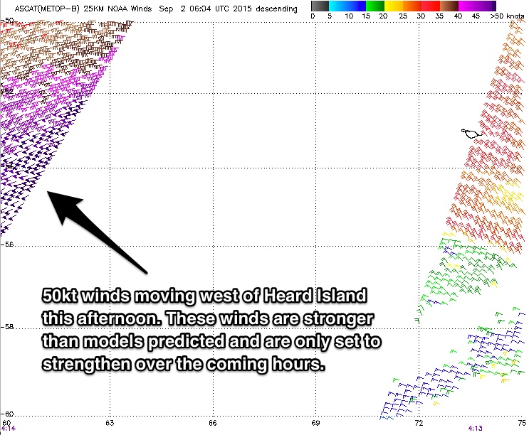
A strong ground swell is still on track to fill in on the weekend. We have observed stronger than forecast winds southwest of Heard Island today (50kt winds with a few 55kt barbs showing up) and this system is only expected to intensify into Thursday.
The long period forerunners look to fill in across the South West late on Saturday afternoon/evening (winds will be fresh/strong west/southwest so it’s not worth considering) with the bulk of the swell due on Sunday (peaking over night). Models have ramped the size up since the last forecast, with 12-15ft likely across the South West and 3-4ft for Perth and Mandurah on Sunday, much larger at the offshore bombies.
Due to the fresh/strong onshore the day before, there is likely to be some residual scarring/short range chop in the mix on Sunday morning right along the coast, but winds are looking light under a ridge.
The South West is likely to be under a light west/southwesterly breeze early, swinging through to west northwest in the afternoon. Perth and Mandurah will be light east/northeasterly early, tending light/variable-northerly in the afternoon. The set up isn’t perfect, but compared to the previous large swell events it’s an improvement. Plus, it’s the weekend so it’s worth keeping an eye on.
Next week (Monday 7th onward):
A trailing fetch following this strong frontal progression will work on an active sea state to maintain plenty of energy throughout the following days. The surf will slowly fade throughout Monday to around 8-10ft across the South West with 2-3ft surf for Perth and Mandurah.
By this stage, a ridge should have become well established over the region leading to light east/northeasterly breezes early tending variable in the afternoon for the South West and light variable winds tending southerly for the Metro stretch.
Tuesday will ease further to around 5-6ft for the South West and 1-2ft for Perth and Mandurah with a subtle period pulse generated by a northwesterly pre-frontal fetch on Sunday.
The South West will be under a light/moderate northeasterly breeze early, tending northerly late, while Perth and Mandurah will see easing northeaster lies tending light northerly late.
A second southwesterly trailing fetch will maintain surf in the 5-6ft range throughout Wednesday across the South West, and 1-2ft for Perth and Mandurah.
Winds will be pretty dicey on this day, moderate/fresh northerly early for the South West for most of the day while the metro stretch will be under a moderate north/northeasterly breeze early, easing and tending northerly late.