Oversized swells with outstanding conditions Saturday

Western Australia Surf Forecast by Craig Brokensha (issued Wednesday 24th June)
Best Days: Friday through Sunday for experienced surfers only, Monday morning
Recap
Great waves yesterday with an easing S/SW groundswell from the 6ft range in the South West, 2-3ft around Mandurah and 2ft+ up at Perth under offshore winds.
Today the swell was smaller again with early favourable winds but these have since increased from the north.
 This week and weekend (Jun 25 - 28)
Give tomorrow a miss as onshore winds will spoil the South West, while further north the swell will be cleaner but tiny early.
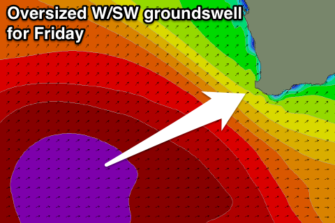
Our large pulses of W/SW and SW groundswell for later tomorrow and more so Friday and Saturday are still well on track.
One of the strongest and broadest polar frontal progressions we've seen for a few years is currently moving through the Indian Ocean, all thanks to a strong node of the Long Wave Trough.
The initial long-period fore-runners are due to hit the Margaret River region at 25s tomorrow morning but with no real size, jumping later in the day to 6-8ft+ across exposed breaks, 2ft in Perth and more so overnight in the North West.
A peak is due through Friday but it's hard to pin down when this will occur.
We're probably looking at the swell ebbing and pulsing between 12-15ft all day across most breaks in the South West with much larger surf at offshore bommies, and 3-4ft around Perth, with rare bigger bombs at swell magnets.
The North West is due to kick through the day, reaching 10-12ft on dark and holding that size most of Saturday.
The secondary large more SW pulse due Saturday morning is being generated by the stalling polar frontal progression between Heard Island and us, producing a broad and expansive fetch of severe-gale SW winds that will migrate towards us this evening before weakening tomorrow.
This swell is expected to come in at a similar size to Friday's with 12-15ft surf in the South West and much bigger waves at offshore bommies, 3-4ft waves in Perth, easing through the afternoon and then further down into Sunday.
Sunday will be softened slightly by a third large pulse of SW groundswell, produced by a vigorous polar low spawning off the main frontal progression and generating a strengthening fetch of severe-gale to storm-force SW winds late in our swell window tomorrow and Friday.
This should keep 10-12ft sets hitting exposed spots early Sunday, dropping through the day and further Monday, with easing 3ft+ sets around Perth and easing 8-10ft waves in the North West.
Conditions on Friday are looking best in protected spots in the South West with a fresh but easing S/SE tending SE breeze, while further north, Perth should see offshore E/SE tending S/SE winds.
Come Saturday, conditions are looking amazing with a moderate to fresh offshore E'ly tending tending variable breeze.
Sunday is then due to see moderate to fresh E/NE tending variable winds.
Next week onwards (Jun 29 onwards)
As the swell continues to ease into next week, winds will continue to swing more NE, but be E/NE at dawn, and then N'ly into the afternoon, limiting surfing options a little.
One final pulse of decent SW groundswell is due later Monday and Tuesday morning, produced by a pre-frontal fetch of W/NW and smaller trailing fetch of SW winds over the coming days.
This isn't due to deliver too much size with Margs expected to ease from the 6ft range Tuesday morning, 2ft+ in Perth and the North West not due to see much size at all.
Winds looks generally favourable at dawn and E/NE before swinging northerly again through the afternoon (Margs may be NE from dawn).
Longer term a cut-off low is due to form to our west through next week bringing deteriorating conditions and some possible N/NW swell with a better SW groundswell in the mix Thursday/Friday, but we'll have a closer look at this Friday.
Comments
22s fore-runners on the Cape Naturaliste buoy this morning, and solid 6ft+ sets already on the Margs cam. Hard to atribute that to a shorter-period building W/SW swell or the long-range energy.