Poor weekend, fun Tuesday, very large late week

Western Australia Surf Forecast by Craig Brokensha (issued Friday 19th June)
Best Days: Tuesday morning, Friday afternoon for experienced surfers, Saturday week morning
Recap
Perth and Mandurah remained clean but tiny yesterday, while Margs picked up an acute N/NW swell off a cut-off low stalling to our west the last few days. I wrote-off any chance of this swell making it to the South West with it being better aimed into the central to northern reaches of the state. Alas funky, clean and peaky 3-4ft waves pushed their way down the coast under offshore winds.
Today the swell was gone and a strong new building S/SW groundswell was seen across the South West with clean 4-5ft waves early. The swell's kicked further through the day but winds have gone more N'ly. Perth was tiny and average with a N/NE breeze, but 2ft sets are now showing across the coast.
This weekend and next week (Jun 20 - 26)
This afternoon's building S/SW groundswell is due to ease back through tomorrow across all locations (peaking early in the North West to 4-6ft). Margs should ease from 4-5ft or so, Perth 1-2ft but conditions will be poor with a fresh W/NW wind (NW around Perth).
While on Wednesday, Sunday's building S/SW windswell was downgraded, we've now seen the frontal system pushing into the coast upgraded again, bringing a solid and large kick in S/SW windswell later Sunday and Monday morning across the South West.
This will be generated by a fetch of S/SW gales pushing into the coast, but conditions will be poor with the associated gale-force W/SW tending SW winds.
What this also means is that winds will remain poor into Monday as some longer-range S/SW groundswell fills in behind the windswell. Strong S/SW tending fresh S'ly winds are due Monday and then Tuesday looks better with light offshore E'ly winds, tending variable around Perth but NW around Margs with another approaching front.
Monday's S/SW windswell should ease from 6ft+ in the South West and 2ft+ in Perth with the S/SW groundswell for the afternoon holding a similar size.
Come Tuesday we should see the S/SW groundswell ease from a similar 5-6ft+ at exposed spots in the South West, 2ft in Perth. The North West should see the swell building Tuesday, reaching an inconsistent 3-5ft and then easing from 3-4ft Wednesday morning.
 Wednesday and Thursday look to be poor in the South West with strengthening onshore winds related to a series of fronts pushing in from the west, while Perth may see variable winds. No noticeable swell is due until Thursday afternoon though.
Into the end of the week and weekend we've got some very large and powerful surf on the way.
As touched on the last few updates, a strong node (peak) of the Long Wave Trough (right) will move through the Indian Ocean later in the weekend and early next week before pushing across us later in the week/next weekend.
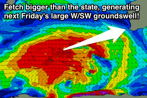
With this, a flurry of very strong, broad and expansive frontal activity will fire up in our swell window, generating at least one, if not a couple of large W/SW groundswell pulses for Friday and the following weekend.
An initial polar low is forecast to generate a fetch of storm to hurricane-force W/SW winds and active sea state for then a broader, elongated but weaker fetch of severe-gale W/SW winds to push over.
This will generate an oversized W/SW groundswell building Friday, peaking at this stage overnight and then tailing off slowly through the weekend, followed by another possible large swell Monday week. Indo will also see this swell, the biggest of the season thus far.
Size wise, we're looking at Margs reaching an inconsistent 12-15ft at exposed breaks Friday afternoon with 20-25ft+ sets at offshore bomboras and reefs.
Winds are looking to tend variable into the afternoon as well as a ridge of high pressure moves in from the west.
Perth should build to an infrequent 3-4ft with the North West kicking to 8-10ft, peaking Saturday to 10-12ft or so.
Saturday looks to see the return of freshening NE winds, but we'll have to review this again Monday. Have a great weekend!