Good swell tomorrow, larger swell Friday but with poor winds

Western Australia Surf Forecast by Craig Brokensha (issued Monday 15th June)
Best Days: Tuesday, Wednesday in protected spots
Recap
Average small waves into Saturday with a fun kick in swell for Sunday in the South West with favourable winds. The swell has eased back into today with straighter offshore breezes, and swell magnets were the pick.
This week and weekend (Jun 16 - 21)
Our strong and inconsistent SW groundswell due through tomorrow is still on track with Margs expected to build through the day and offering inconsistent 6ft sets into the afternoon with the possibility of the odd bigger bomb, 2ft+ waves in Perth and kicking late to 3-4ft+ up in the North West, peaking early Wednesday to 4-5ft+.
Winds tomorrow will be fresh from the E/NE through the morning, tending NE at times through the day around Margs and then back to the E/NE into the evening.
Wednesday will see deteriorating conditions with a stronger NE wind across the South West and E/NE winds in Perth with N/NE tending N/NW winds up around the North West. Therefore you'll have to hunt down a more protected break around Margs for the best conditions.
Into Thursday the groundswell will continue to ease, but some new W/NW swell should be seen building across Perth, and from the W/SW up in the North West. This will be from the northern flank of a slow moving and stationary cut-off low to our west over the coming days, although winds will be poor with N/NE tending N/NW winds due across most locations (holding from the NE all day around Margs).
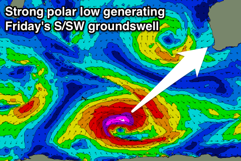 As touched on last update, a strong pulse of S/SW groundswell is due through Friday but winds are looking dicey as the low slowly pushes across us, bringing NW tending W/NW winds. This swell however will be produced by an intense polar low forming to our south-west this evening, projecting a fetch of severe-gale to storm-force W/SW winds through our swell window before pushing east and under the country.
A large S/SW groundswell should result, peaking through Friday in the South West and building during the day in Perth, not arriving till dark in the North West and peaking Saturday.
Exposed breaks should see 6-8ft sets in the South West, with Perth building to 2ft and the North West peaking in the 4-6ft range Saturday morning.
This swell is then due to ease into the weekend but winds will remain poor and onshore from the W/NW Saturday, strengthening from the W/SW to S/SW through Sunday.
Next week onwards (Jun 22 onwards)
Sunday's strong S/SW change should bring with it a local increase in S/SW windswell followed by S/SW groundswell early next week as winds slowly improve. Tuesday looks the best day to surf as strong S/SE winds Monday ease and tend more SE.
Some stronger and fairly northern frontal activity is then due to follow into the middle to end of next week, with plenty of W/SW groundswell on the cards. We'll have to have a closer look at this on Wednesday though.
Comments
That new SW groundswell is pushing in strongly now across the South West..