Large swells with improving conditions, more so next week in South West

Western Australia Surf Forecast by Craig Brokensha (issued Wednesday 3rd June)
Best Days: Perth and Gero early tomorrow, early Friday, Sunday morning, everywhere Monday and Tuesday mornings
Recap
Building levels of windswell across all coasts yesterday, becoming larger through today and into this afternoon but with no decent options for a clean wave.
This week and weekend (Jun 2 - 7)
The swell seen building across the coast the last day or so has been mainly low period windswell, but stronger levels of groundswell from the parent frontal progression is due to fill in tomorrow and Friday across all regions, offering larger 8-10ft sets across the South West, continuing 3ft waves in Perth and 5-6ft waves up at Gero.
Winds will remain poor and onshore from the NW around Margs tomorrow, with an early N/NE breeze due around Perth and NE winds up at Gero, creating cleaner conditions.
Friday morning should see a better E/NE breeze around Perth at dawn, NE up at Gero before an onshroe W/NW breeze moves in, but without much strength. Margs is expected to remain average with a NW tending SW breeze.
Into the weekend onshore winds will re-develop across Perth with only a slim chance of a variable wind at dawn, and more likely a SW'ly. Margs will see fresh W/NW tending W'ly winds as the next front pushes in.
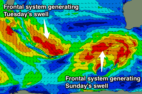
This front will be linked to another large pulse of W/SW groundswell, with the swell due to build through Saturday afternoon and peak Sunday to 8-10ft in the South West, 2-3ft in Perth and 5-6ft up at Gero.
Winds will be good Sunday morning for Perth and offshore, SE up at Gero, while Margs looks to see a lingering SW'ly across most of the Cape, with possible variable breezes to the north.
 Next weekend onwards (Jun 8 onwards)
Monday will be the day to surf in the South West as Sunday's W/SW groundswell eases and winds swing offshore from the E/NE. Exposed breaks should still be in the 8ft range with 2-3ft sets around Perth.
Another new SW groundswell is due later in the day but more so Tuesday, produced by a strong pre-frontal fetch of W/NW gales moving to our south-west during Sunday and Monday.
This should keep Margs ticking around the 6-8ft+ range with 2ft+ sets in Perth under E/NE tending NE winds, which aren't as favourable.
Longer term a new W/SW groundswell is on the cards for Thursday next week, but we'll have a closer look at this on Friday.