Fun Saturday, poor, large and onshore most of next week

Western Australia Surf Forecast by Craig Brokensha (issued Friday 29th May)
Best Days: Saturday and Sunday morning exposed breaks, Thursday morning
Recap
Yesterday played out pretty much to script with a large and building S/SW groundswell across the state, although conditions were better than expected through the morning around Margs. Afternoon S/SE winds focussed the attention to protected breaks which pumped until dark. Perth remained clean into the afternoon when the swell peaked, while this morning, everywhere was pumping with easing 8ft+ surf around Margs and 2-3ft sets in Perth.
This weekend and next week (May 30 – Jun 5)
Over the weekend today's large S/SW groundswell will continue to ease, backing off from 3-5ft tomorrow morning and then down to a smaller 3ft into Sunday. Perth will become tiny and Gero should be fun. Conditions will be great for exposed breaks tomorrow with an E/NE offshore, giving in to a late sea breeze and then variable tending W'ly breezes Sunday.
Monday will be worth giving a miss as the swell continues to ease under strengthening N/NE winds.
We've got plenty more action on the cards from Tuesday though with a mix of long-range W/SW groundswell and local windswell building ahead of some large and stormy W/SW swell into Wednesday and Thursday.
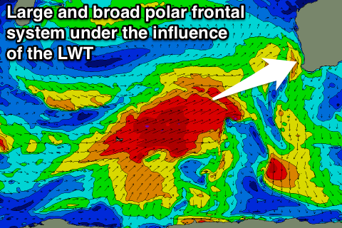
This will be related to a strong node of the Long Wave Trough moving in from the west during next week and pushing across us later in the week.
This will initially project a series of vigorous polar fronts up towards us over the weekend and early next week, before moving across us during the middle of the week bringing onshore winds.
Size wise the first pulse for Wednesday is due to build to 10-12ft across Margs with 3ft surf in Perth and 6-8ft waves up at Gero but with poor and weakening onshore W/NW tending W/SW winds.
The swell is due to drop a touch into Thursday and there may be a small window of variable winds during the morning in between frontal systems.
The fronts and swells are then due to settle down into the end of the week and following weekend as the LWT pushes further east, with improving conditions.
We're likely to see a strong new W/SW groundswell for Monday week, but we'll have a closer look at this on Monday. Have a great weekend!