Easing surf, ahead of some better swell next week as winds go onshore

Western Australia Surf Forecast by Craig Brokensha (issued Wednesday 20th May)
Best Days: Exposed breaks tomorrow and early Friday around Margs, Saturday and Sunday morning's in the South West, early Monday all regions
Recap
Small workable waves across both coasts yesterday morning with SE winds and a mix of easing SW swell and late kicking S/SW groundswell.
The S/SW groundswell has peaked in the 6ft+ range this morning across the South West with 1-2ft sets around Perth under offshore E/NE winds. The swell has started to ease around Margs but winds are still favourable and offshore.
This week and weekend (May 21 - 24)
Into the end of the week we'll see the swell easing out of the S/SW under favourable E/NE tending NE winds tomorrow and E/NE tending N/NE winds Friday.
Into the weekend a very long-range and inconsistent SW groundswell is due across exposed breaks, generated last weekend to the south of South Africa. This swell should build slowly through Saturday and reach an inconsistent 3-4ft+ into the afternoon across exposed breaks with 1ft sets in Perth. A slight drop is then due through Sunday.
Winds will go a little funky with a variable but offshore breeze due Saturday morning ahead of afternoon onshores and then offshore breezes again Sunday morning ahead of weak afternoon sea breezes.
 Next week onwards (May 25 onwards)
Into next week we've finally got some better swell activity on the way.
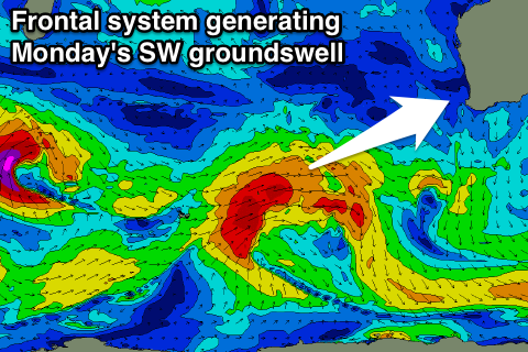
The first swell will be an inconsistent but good SW groundswell, generated by a long-lived frontal progression pushing east towards us over the coming days.
A fetch of gale to severe-gale-force W/SW winds will be projected towards us, generating a large and inconsistent SW groundswell for Monday.
Margs should come in 6ft with the odd bigger 8ft set at times, with Perth showing 2ft sets, while Gero should kick to 3-5ft late in the day. Winds are looking favourable with early offshores ahead of a SW change.
Behind this initial frontal progression a secondary weaker frontal system should produce a secondary more consistent SW swell for Tuesday, but this front will push into us as the same time, bringing strong onshore winds and some local windswell.
A mix of SW swells to 6-8ft is due in the South West with 2ft+ waves in Perth but with strong S/SW winds.
Longer term another large S/SW groundswell for Thursday but winds may linger onshore from the SW. We'll confirm this Friday.
Comments
Craig when are the shitmixers coming...we need a bank shakeup!
Looking for a week of sustained strong NW winds please.
Nothing of this ilk showing over the coming couple of weeks unfortunately.