Large easing swell with improving winds from Friday

Western Australia Surf Forecast by Craig Brokensha (issued Wednesday 22nd April )
Best Days: Thursday protected spots, Thursday onwards everywhere
Recap
Yesterday was small and clean across the South West, but today a strong new SW groundswell started to build under strong offshore winds. The swell quickly built to 6-8ft through the day and a further increase in size to the 10ft range on the sets has been seen this afternoon as winds eased and tended more variable. We should see a weak sea breeze into the afternoon, favouring protected breaks.
 This week and weekend (Apr 23 – 26)
Today's large building SW groundswell is due to peak this evening and ease through tomorrow across all regions. Margs should ease from 8ft+, Perth from 2ft to possibly 3ft and 4-5ft up at Gero.
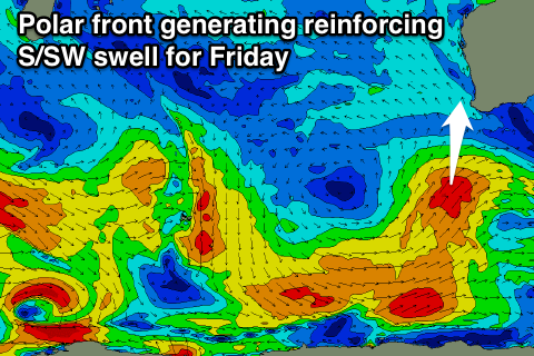
The easing trend will be softened through Friday and the weekend as a moderate to large sized S/SW groundswell fills in, generated by a polar front pushing up towards us this afternoon and early tomorrow.
Margs should continue to offer 6ft sets Friday morning with inconsistent 2ft waves in Perth and 3-4ft sets up at Gero before easing into the afternoon and down further into Saturday and then Sunday.
Winds will be average tomorrow and strong from the SE favouring protected spots, with better but still strong E/SE winds across Margs Friday and E'ly breezes north around Perth and Gero.
Saturday should see fresh to strong and easing E/NE winds with Sunday playing out similarly.
Next week onwards (Apr 27 onwards)
The swell will bottom out through Monday and Tuesday with winds from the north-eastern quadrant, while we should see some better swell activity from Wednesday afternoon and into the end of the week as a new node of the Long Wave Trough moving in from the west brings with it some better polar frontal activity. More on this Friday though.