Large swells to continue

Western Australia Surf Forecast by Craig Brokensha (issued Wednesday 15th April )
Best Days: Every day over the coming period
Recap
Slow start to yesterday ahead of a good pulse of SW groundswell in the South West as a strong S'ly change pushed through.
Today a new large and powerful SW groundswell filled in, building from an inconsistent 6ft to occasionally 8ft this morning to 8-10ft+ this afternoon in the South West, while we should see Perth building to 2-3ft. Conditions were clean through the morning but fresh sea breezes have since kicked in.
 This week and weekend (Apr 16 – 19)
Today's SW groundswell is the first of a series of large swells due across the state, and we'll see the second pulse fill in through tomorrow afternoon. This swell was generated through yesterday and this morning by a vigorous polar low to our south-west.
Margs should drop back temporarily to the 8ft range tomorrow morning before pulsing back to 10ft into the afternoon. Perth should persist in the 2-3ft range all day, while Gero should see 4-6ft waves through the morning, with the new swell arriving late in the day.
A peak in size is due into the evening with Margs easing from the 10ft range Friday morning, Perth from 2-3ft and Gero from 4-6ft again.
Winds are looking great tomorrow with a moderate E'ly offshore in the South West, fresher from the E/SE around Perth and Gero. Afternoon sea breezes are due in the South West with S/SE winds further north.
Friday will be clean again with a light offshore E/NE wind in the South West, fresher from the E/NE further north ahead of a shallow W/SW change into the afternoon around Margs and sea breezes to the north.
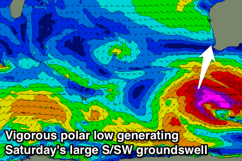
The third and final pulse of large groundswell is due Saturday, coming in from the S/SW and having the largest swell periods of all the swells.
This will be due to the polar low generating the swell producing core wind-speeds up to 50-55kts through our swell window, with the bulk of the energy being aimed into Southern Australia.
Still, we'll see a large S/SW groundswell arriving through Saturday morning, peaking during the middle of the day to 10-12ft+ across exposed spots with larger sets at deep water reefs.
Perth should kick to 3ft+ through the afternoon with a late increase in size up at Gero, easing Sunday from 4-5ft+ Sunday morning.
Winds look to remain good and offshore from the E/NE across all spots before tending variable into the afternoon with the possibility of weak sea breezes.
A steady drop in size is then due through Sunday from 6ft to occasionally 8ft in the South West and 2-3ft up at Perth under fresh NE tending N/NE and then lighter N/NW winds.
Into next week the swell will steady in the moderate size-range, with the next considerable increase in size due Wednesday. This will be related to a couple of strengthening polar fronts firing up from the Heard Island region later in the weekend and into early next week, generating a series of SW groundswell pulses.
The best is due Wednesday, peaking through the middle of the day/afternoon in the 6ft range in the South West, with 1-2ft waves in Perth and 3-4ft sets up at Gero into the afternoon. Winds should be favourable and offshore through the morning ahead afternoon sea breezes, but we'll have a closer look at this on Friday.