Pumping Friday, good again Monday morning

Western Australia Surf Forecast by Craig Brokensha (issued Wednesday 16th March)
Best Days: Thursday in protected spots, Friday morning all locations, Sunday protected spots, Monday through Wednesday all locations as the swell eases
Recap
Poor weak and building windswell across most regions with fresh onshore winds, continuing into today with no quality options for a wave.
This week and weekend (Mar 19 - 22)
All attention should be focussed on tomorrow and more so Friday across the state, with the arrival of a strong and powerful SW groundswell due.
The polar frontal system generating this swell is currently clipping the South West and behind it we should see the groundswell fill in.
The South West is due to peak through the middle of the day to 8-10ft+ across exposed breaks with Perth due to kick to 2-3ft through the middle of the day/afternoon and Gero up to 3-5ft late.
Friday morning should then see the swell ease away from 6-8ft at exposed breaks around dawn in the South West, 2-3ft in Perth and 4-6ft up at Gero.
Winds tomorrow are best for protected locations in the wake of today's front with a S/SW tending S'ly beeze in the South West, swinging S/SE late in the day and then around Perth S/SE tending S/SW winds. Gero looks better with a light E/SE tending S/SW wind.
Friday should be excellent with straight offshore E'ly winds developing across all locations before afternoon sea breezes kick in.
 Saturday is looking average still as the swell backs away further as winds make a turn for the worse, blowing from the S-S/SW as a surface trough drifts in from the west.
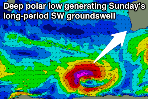
Sunday should see the return of strong SE winds and a strong new long-period S/SW groundswell, generated over the coming days by an intense polar low. This low should develop today along the Polar Shelf south of Heard Island and generate a tight fetch of severe-gale W/SW winds through our swell window.
It will then broaden while weakening to our south-west Friday with a strong long-period S/SW groundswell due to spread up and towards us for Sunday.
The South West should peak through the day to an inconsistent 6-8ft at exposed breaks with Perth coming in at 2ft+ and Gero kicking to 3-5ft.
Monday onwards (Mar 23 onwards)
Sunday's swell will tail off through early next week (although Gero will see moderate amounts of S'ly windswell Monday morning) and winds should improve, swinging back to the E/SE but with strength Monday morning and persisting into Tuesday and Wednesday mornings.
Longer term there's nothing too major on the cards at all for next week, so make the most of the coming swells.