Fun waves over the coming period

Western Australia Surf Forecast by Craig Brokensha (issued Monday 9th February)
Best Days: Every morning besides Friday
Recap
The Margs region offered fun waves over the weekend with small to moderate amounts of swell and offshore winds which were a bit too strong early each morning. Perth was still in the 2-3ft range Saturday before backing off to 1-2ft Sunday.
Today the swell steadied but winds were average and onshore across most locations besides Gero which saw a period of lighter S/SE winds early.
 This week (Feb 10 - 13)
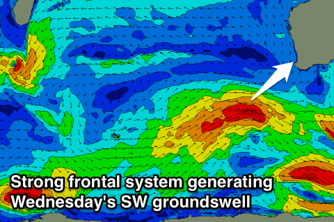
Our two pulses of SW groundswell due tomorrow and Wednesday are still on track, with tomorrow's increase being longer-period and less consistent while Wednesday's will be bigger, more consistent and with better local offshore winds.
Size wise, tomorrow's swell should come in at 4-6ft in the South West from mid-morning, 2ft+ in Perth from midday and 3-4ft up at Gero through the afternoon, while Wednesday should offer larger 5-6ft+ surf in Margs, 2-3ft waves around Perth and 3-5ft sets up at Gero (peaking through the middle of the day).
Winds tomorrow will be average and from the S/SE across Margs and Gero through the morning, while Perth should see a more favourable E/SE'ly early. Wednesday looks best with offshore E/SE winds in the South West and Gero, while Perth should see straight E'ly winds.
On the backside of the swell Thursday winds should be offshore again in the South West and up at Perth, but Gero looks to offer less favourable S/SE winds. Friday will then be average with leftover amounts of swell and S/SW winds.
This weekend onwards (Feb 14 onwards)
From Saturday we should see a couple of good pulses of SW groundswell across the state, the second arriving Monday afternoon.
The first should be generated by a short-lived but strong front pushing in from the west later this week, kicking up a short-lived SW groundswell for Saturday, pulsing to 4-5ft+ around Margs later in the day, 2ft in Perth and 3-4ft up at Gero Sunday morning.
The second swell will develop from a strong and slow moving polar low forming south-west of us over the weekend, aiming a fetch of severe-gale to storm-force W/SW winds through our south-western swell window.
This swell at this stage is due to arrive later Monday and peak overnight in Margs and Perth but with a touch more size than Saturday's swell. Winds at this stage look best Sunday morning, but we'll have another look at this again on Wednesday.