Fun Wednesday morning, better Sunday morning

Western Australia Surf Forecast by Craig Brokensha (issued Monday 13th October)
Best Days: Tuesday morning exposed breaks, Wednesday morning, Sunday morning
Recap
The weekend started poor in the South West with a large building swell but onshore winds. While Perth and Gero were cleaner and fun early with good winds before onshore S/SW winds kicked in. A late S'ly change in the South West opened up protected spots for a dusk session, but Sunday morning was the time to surf with excellent conditions under straight offshore E'ly winds that persisted into the late afternoon (Gero saw less favourable S/SE winds).
This morning was great again with easing levels of swell from 5-6ft in the South West, 2ft sets in Perth while Gero remained less than ideal in the 3-4ft range.
This week (Oct 14 - 17)
The swell will continue to ease through tomorrow and bottom out during the middle of the day, becoming small across all coasts. Winds will be favourable again and offshore from the E/NE across most locations ahead of afternoon sea breezes.
A fun new SW groundswell is due into the late afternoon, peaking Wednesday morning in the 6ft range across the South West, 2ft in Perth and 3-4ft up at Gero.
Winds look a little funky with a deepening low pressure trough across the central coastal district with fresh E/SE winds around Margs, E/NE in Perth and E'ly in Gero before tending W'ly.
Into Thursday another slightly bigger SW groundswell is due across the state from a strong frontal progression that's currently to our south-west. This will come along with average winds though as a weakening trough from the progression pushes across us, with S/SE tending S/SW winds across the South West and onshores further north. These onshores look to persist into Friday before swinging back offshore from the SE Saturday as the swell bottoms out.
This weekend onwards (Oct 18 onwards)
While the swell will bottom out into Saturday morning, a new medium-large SW groundswell is due through the afternoon before peaking overnight and easing Sunday.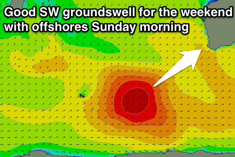
This will be generated by a favourably tracking polar front pushing from the Heard Island region up towards us while producing a fetch of SW gales over the coming week.
This swell should come in the 6ft+ range in the South West, 2ft+ in Perth and 3-5ft up at Gero Sunday morning with good E/SE winds.
After this there's nothing major on the cards so make the most of the small windows of waves over the coming period.