Oversized W/SW swell Friday afternoon with light winds

Western Australia Surf Forecast by Craig Brokensha (issued Wednesday 20th August)
Best Days: Friday afternoon, Saturday, Sunday-Monday morning Perth and Gero, Tuesday
Recap
The South West and Gero saw poor conditions through yesterday, while Perth offered fun waves with light variable breezes through the day.
Today a new SW groundswell has filled in keeping fun waves hitting Perth to 2ft with 3-5ft sets around Gero, while a light NW wind created less than ideal conditions around Margs.
This week and weekend (Aug 21- 23)
Thursday is still looking to be a write-off across all locations as a front moves through, bringing fresh and gusty N/NW tending W/NW winds.
Of much greater importance is Friday's swell, with it being upgraded and coming in stronger than the secondary pulse due on Tuesday.
Since Monday, a vigorous polar front firing up south-east of South Africa has pushed east-northeast up towards us under the effects of the Long Wave Trough while generating a very broad and elongated fetch of severe-gale W/SW winds.
This system is currently stalling to our west-southwest, with a secondary intensification expected to project a further fetch of severe-gale to near storm-force W/SW winds right towards us this evening and tomorrow.
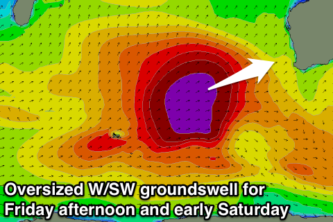 An oversized W/SW groundswell will result that's expected to arrive through the middle of the day Friday and build very rapidly during the afternoon, peaking overnight.
Margs should build to 12-15ft late in the day, with much bigger surf at offshore reefs and bommies, while Perth should increase to 3-5ft and Gero to 8ft+ (bigger at offshore reefs).
Winds will be onshore during the morning and fresh from the SW but easily rapidly as a ridge of high pressure moves in, with light variable breezes due into the afternoon as the swell kicks. This should see improving conditions across all coasts.
A steady drop in size is due across all coasts Saturday, although a peak is likely early in Gero to 8-10ft with much bigger waves at offshore reefs.
Winds will be great for Perth and Gero with offshore E/NE and E/SE winds respectively, while Margs looks average with an early N/NE'ly expected to quickly freshen from the NW during the day.
Sunday will remain poor in the South West with fresh N/NW winds, but Perth and Gero should see variable breezes during the morning creating clean conditions.
Next Monday onwards (Aug 25 onwards)
Onshore NW winds will continue in the South West Monday with moderate to large amounts of the swell, as Perth and Gero see morning offshore NE winds.
An overnight change is due though as a cold front clips the state, and behind this we'll see a secondary large W/SW groundswell filling in across the state.
This swell will be a touch smaller than Friday afternoon's kick due to the system generating it not being as long lived, but wind speeds are expected to be slightly stronger for longer.
A peak to 12-15ft is expected in the South West Tuesday with 3-4ft waves in Perth and 8ft+ waves into the afternoon around Gero under light variable tending offshore winds north of Margs and SE winds. We'll confirm this all again on Friday though.