Limited options this week, pumping Sunday

Western Australia Surf Forecast by Craig Brokensha (issued Friday 1st August)
Best Days: Early Tuesday, Friday morning for keen surfers, Saturday morning, Sunday
Recap
Saturday was a good rest day with funky winds and a low point in swell across the South West, while further to the north, conditions were better through the morning.
Into Sunday though a large and powerful W/SW groundswell started to fill in, jumping to an easy 10ft+ through the afternoon in the South West under offshore tending variable winds. The swell also kicked strong further north under similar conditions.
Today a secondary large reinforcing has kept 8-10ft+ sets hitting the South West with 3ft surf in Perth as offshore winds continued to create excellent conditions. This has topped off a pumping period of waves across West Oz since last Friday morning.
This week (Aug 4 – 8)
Make the most of today's swell and conditions as over the coming days winds will go more north with a slow but steady drop in size.
Early tomorrow at northerly friendly breaks will be the go, but the swell will likely still be too big in the South West. Perth should see E/NE winds early before swinging more NE through the morning and N'ly into the afternoon. Similar conditions are due into Wednesday but with fresher N'ly breezes through the afternoon.
A weak change on Thursday should bring weak onshores to the South West and Perth, but Gero may see an early NE'ly. The swell will be slow with background levels of SW groundswell keeping most locations topped up with small waves.
Friday should be cleaner with light variable tending local offshore winds but a slow 3-5ft of swell in the South West, 1-2ft in Perth and 3ft around Gero.
This weekend onwards (Jul 9 onwards)
As touched on last update another large and powerful SW groundswell is expected this coming weekend.
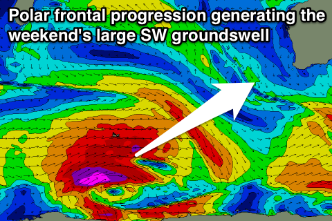 The origins of this swell is a vigorous polar frontal progression firing up west of Heard Island today and pushing slowly east while producing a fetch of severe-gale to sub-storm-force W/SW winds through our swell window right up until Friday.
A large and powerful long-period SW groundswell will result, arriving overnight Friday and peaking Saturday afternoon to 10ft to occasionally 12ft at exposed spots in the South West, 3ft in Perth and 6-8ft on dark in Gero.
Winds look to be good and offshore from the E/SE across the South West and Perth Saturday morning with SE winds around Gero while Sunday looks excellent with E'ly winds expected across all locations with a large easing swell. Check back here on Wednesday for confirmation on this though.