Large and onshore, cleaner to the north

Western Australia Surf Forecast by Craig Brokensha (issued Wednesday 23rd July)
Best Days: Monday around Gero, Tuesday around Gero and Perth, Wednesday, later in the week
Recap
The South West continued to offer poor conditions yesterday morning, but onshore winds eased into the afternoon with a slight kick in swell, improving conditions slightly.
Perth and Gero saw better conditions with variable tending light offshore winds, but the surf and ocean was still quite lumpy/wobbly and all over the place.
Today an inconsistent long-range W/SW groundswell is providing more size across all coasts, but winds strengthened from the NW in the South West, leaving no options for a wave, while lighter N'ly winds to the north have since started strengthening from the N/NW.
This weekend onwards (Jul 21 onwards)
There's tons of swell on the way for our state for the next two weeks but through this weekend and next week, onshore winds will spoil the party.
Tomorrow's large and powerful W/SW groundswell to 12-15ft in the South West, 3-4ft in Perth and 6-8ft+ up at Gero will arrive with fresh to strong NW tending W'ly winds across most spots (W/SW into the afternoon around Perth).
This swell should ease through the afternoon, but a secondary broad front slamming into the state on Sunday will bring with it a renewal of large W/SW groundswell energy for the afternoon as winds persist from the western quadrant.
Sunday afternoon's large kick in swell will drop back slowly through Monday and Tuesday but moderate to fresh W'ly winds will continue in the South West and likely around Perth, while Gero will perform the best with morning variable breezes.
Tuesday is probably your best chance to aim for a surf around Perth as winds tend variable with 3ft of swell. Gero should be great with light offshore E/SE winds and 6ft+ of SW groundswell.
Into the second half of next week we'll see the swell swing more SW in direction as the storm track focusses more up towards SA and Vic, with a very strong polar front due to fire up just within our swell window.
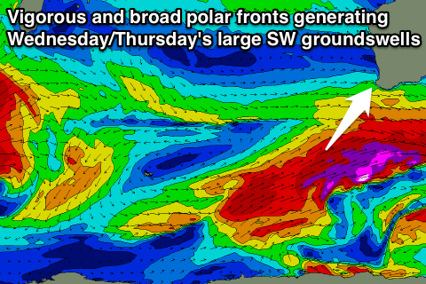 This should produce a large SW groundswell for Wednesday in the 10ft+ range for the South West, 3ft+ around Perth and 6ft+ up at Gero before dipping back every so slowly through Thursday and Friday.
With the frontal activity shifting off to the east we'll see a ridge of high pressure quickly move in, swinging winds around to the S'th Thursday and then Friday we should see E/NE winds developing across most spots.
Beyond this another series of very large and powerful long-range W/SW groundswells are due through the following week, but we'll look at this in more detail Monday. Have a great weekend!