Great waves Friday and early Saturday, large swells next week

Western Australia Surf Forecast by Craig Brokensha (issued Wednesday 9th July)
Best Days: Thursday mroning, Friday, early Saturday, Tuesday and Wednesday (check back Friday)
Recap
A large and powerful mix of SW groundswell and windswell pushed into all coasts yesterday, but it was only super protected bays and points that offered any decent quality waves as winds tended more S'ly into the afternoon.
A ridge of high pressure quickly sliding in from the west today caused winds to tend light offshore across most locations with improving conditions right through the morning and into this afternoon with a large easing swell.
This week and weekend (Jul 9 – Jul 13)
A further drop in swell is due across the state tomorrow and winds in the South West are now looking better with a weak front clipping the southern tip of the state coming in even weaker.
This should result in variable, likely tending E/NE winds tomorrow morning before shifting W'ly into the afternoon. Further north offshore tending variable winds are due.
Friday's large kick in SW groundswell is still on track and we should see Margs building back to 6-8ft at exposed breaks during the afternoon, with Perth building to 2ft to nearly 3ft, and then 4-5ft later up at Gero.
Winds should be favourable all day as the weak front moves off to the east and winds swing offshore from the E/NE tending E/SE across most spots. Geraldton will probably see less favourable S/SE winds into the afternoon though.
Into the weekend the swell will drop away and winds will become unfavourable from the northern quadrant. Early Saturday will be your best bet in the South West with an early E/NE'ly before freshening from the N/NE. Further north conditions will be good for most of the day. Sunday will see winds going terrible from the NE to N/NW everywhere, so it's probably worth giving a miss.
Next week onwards (Jul 14 onwards)
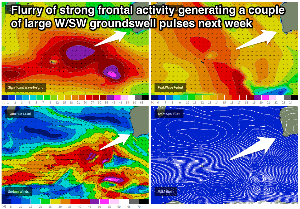 Another strong amplification of the Long Wave Trough is forecast to move into from the Southern Indian Ocean through Friday and the weekend and with this we'll see a flurry of very strong and powerful frontal activity.
A couple of large W/SW groundswell pulses are on the cards for Tuesday and Wednesday and we may be blessed with favourable winds as the fronts fail to really impact our region once they've generated their swells.
We'll look at this more on Friday but Wednesday could be quite special indeed.