Pumping Thursday, stormy from then onwards

Western Australia Surf Forecast by Craig Brokensha (issued Wednesday 2nd July)
Best Days: Thursday, early Friday, Tuesday afternoon onwards
Recap
Gero and Perth fared the best yesterday with early NE winds and small amounts of swell. Today onshores moved in across most of the state and a late increase in strong W/SW groundswell is due, but more on this below.
This week (Jul 3 – Jul 4)
This afternoon's large kick in W/SW groundswell should hold into tomorrow morning and winds are expected to play nice as a ridge of high pressure quickly slides in from the west in the wake of today's onshores.
This should result in winds swinging around to the E/SE across all coasts during tomorrow morning, creating good conditions but the afternoon looks great with winds tending lighter E/NE.
Size wise, the South West should ease from 8ft to possibly 10ft, 2-3ft around Perth and 5-6ft up at Gero.
Friday morning is looking dicey as early and fresh N/NE winds will swing NW and strengthen through the day, so the early will be the go across all regions.
This weekend onwards (Jul 5 onwards)
From this weekend onwards we'll fall under the effects of an amplification of the Long Wave Trough strengthening and moving across us.
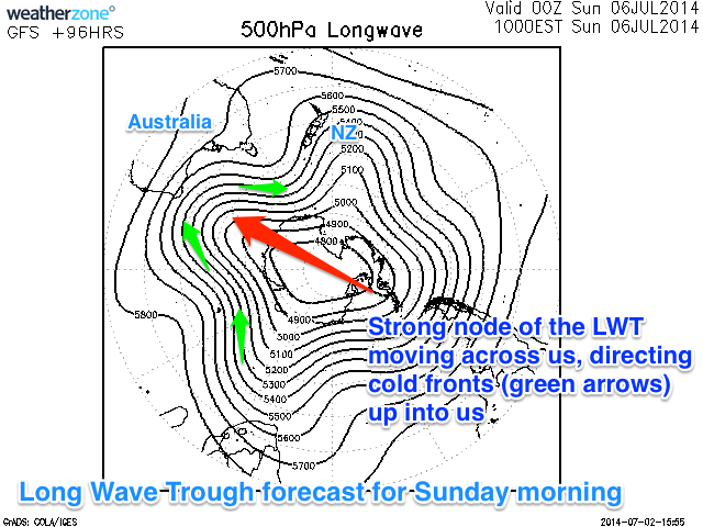 The Long Wave Trough basically steers and strengthens polar fronts up towards a position of just west of where it is sitting (right). With it slowly tracking across us over the weekend and then on towards the Bight early next week, we'll see a series of vigorous polar fronts steered up and into us, generating large and stormy pulses of groundswell.
The first system is currently through the Central Indian Ocean and the large swell from this system will fill in later Saturday and persist Sunday as winds go onshore with the front generating the swell clipping us.
A secondary polar frontal system will then slam straight up into us from the Southern ocean through Monday, kicking up a large and powerful SW groundswell later in the day and Tuesday morning.
This looks to be the strongest of the frontal systems and should produce large waves in the 12-15ft range in the South West, 3-4ft in Perth and 6-8ft around Gero but with gale-force SW winds.
We may see winds swinging late Tuesday to the S'th, opening up protected bays and points for action, but we'll review this Friday.
With the Long Wave Trough passing over towards SA and Vic through the middle of next week, the wave activity will die down and winds should improve, swinging offshore. We'll cover this all again on Friday so check back then for an update.