Average end to the week, improving Sunday

Victorian Forecast by Craig Brokensha (issued Wednesday July 30th)
Best Days: Exposed beaches Sunday and Monday, next Wednesday
Features of the Forecast (tl;dr)
- Small tomorrow wih light-mod E/SE-SE winds
- Inconsistent, moderate sized SW groundswell filling in Fri, peaking through the day, easing slowly Sat with a reinforcing groundswell in the mix
- Moderate SE winds Fri, freshening
- Moderate E/SE winds Sat AM, freshening from the SE into the PM
- Easing surf Sun with local offshore winds (N/NW Surf Coast, N/NE to the east), tending N/NE into the PM
- Smaller Mon with strong N/NE winds
- Moderate sized, inconsistent W/SW groundswell building later Tue, peaking Wed with N/NW-NW winds likely
Recap
Monday’s increase in close-range swell held the peaky 3ft range yesterday morning with offshore winds across the Surf Coast reefs, shifting weak onshore through the afternoon as the swell eased.
Today a trough is bringing deteriorating conditions as onshore winds slowly freshen along with smaller amounts of leftover swell.
This week and next (Jul 31 - Aug 8)
Tomorrow is another so/so day of surf with small waves on the Surf Coast, spoilt by a light to moderate E/SE-SE breeze, while locations to the east should be semi-clean but only small and average to 3ft or so.
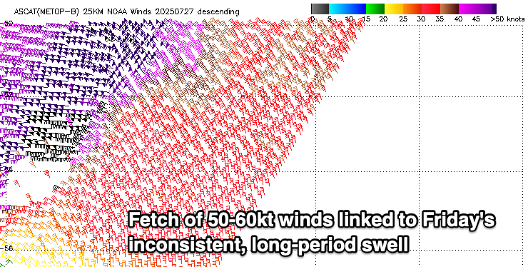
Into Friday our new, inconsistent, long-period SW groundswell is due to arrive, generated by a very strong but short-lived polar low that formed around the Heard Island region earlier this week.
Satellite observations picked up 50-60kt core winds and with this we should see strong but inconsistent sets as it peaks through the day Friday, coming in at 3-4ft on the Surf Coast magnets and 6ft to the east. There’ll be a long wait for these sets though and dawn might be slightly undersized.
A secondary pulse of slightly smaller, reinforcing SW groundswell is due later Friday and Saturday morning, slowing the easing trend from Friday, generated by follow up frontal activity generating gale to severe-gale W/NW winds through our south-western swell window.
This should maintain 3ft+ waves on the Surf Coast magnets Saturday morning with 4-6ft sets to the east, easing through the day.

Looking at the local winds and weak SE winds are due to freshen through Friday, creating average conditions, weaker and tending more E/SE through Saturday morning but still moderate in strength before freshening from the SE into the afternoon.
Sunday is the pick with easing surf and local offshore winds that will tend N/NE into the afternoon. The Surf Coast will likely be peaky with some small SE windswell in the mix, best to the east and easing from 4ft or so.
There is an outside chance of some new, long-period S/SW groundswell for Sunday morning, though the source is a very late forming low to the south of Tassie. EC has it way later and weaker, resulting in no new swell but GFS has a stronger, earlier forming low. For now we’ll side with EC and ignore the pulse.

Into next week, a small reinforcing SW groundswell for Monday under strong N/NE winds should favour the exposed beaches again, with a run of better W/SW groundswell on the cards from later Tuesday but more so Wednesday.
We’re set to see an initial strong polar frontal system projecting up towards Western Australia later this week, generating an inconsistent, moderate sized W/SW groundswell for Wednesday.
A secondary slower moving and stronger frontal progression pushing towards and under the country early next week looks to generate some slightly more consistent, larger W/SW groundswell for later week, but we’ll confirm this on Friday. Winds are still up for grabs as well.