Flukey outlook this week

Victorian Forecast by Craig Brokensha (issued Monday July 28th)
Best Days: Surf Coast for the keen this morning, Saturday morning selected spots, exposed beaches Sunday
Features of the Forecast (tl;dr)
- Weak, easing SW swell tomorrow, mixed in with an inconsistent SW groundswell
- W/NW tending weak S/SW winds
- Smaller Wed with freshening S/SE tending SE winds
- Small Thu with moderate E/SE-SE tending S/SE winds
- Moderate sized, inconsistent SW groundswell for Fri, peaking through the day with freshening S/SE winds
- Secondary pulse of similar sized SW groundswell Sat AM, easing
- Variable E/NE-NE tending SE winds Sat
- Smaller Sun with fresh N/NE winds
Recap
Saturday pumped across the exposed beaches once the morning low tide filled in with mostly clean conditions, 4ft sets and options all over that held into the evening.
Yesterday the wind wasn’t as favourable though selected spots across Phillip Island were still clean and fun, with the Surf Coast offering a bit more energy to 2ft under offshore winds.
Today a weak, localised W/SW swell is on the build (now 2-3ft Surf Coast) with OK winds that will shift more onshore through the day.

Decent size Saturday afternoon
This week and weekend (Jul 29 - Aug 3)
A weak mid-latitude low moving through Bass Strait today will kick up a localised increase in swell today but with no quality or size and with a shift in winds to the W/SW as they strengthen.
The low will clear tomorrow resulting in the windswell easing, though a distant, inconsistent groundswell is expected to also be in the water with slow sets to 2ft+, easing through the day.
A light W/NW morning breeze will favour the Surf Coast with weak sea breezes due into the afternoon.
Come Wednesday, a trough will bring a freshening S/SE tending SE breeze and poor conditions with E/SE-SE winds persisting into Thursday.
Swell wise no major energy is due through these days, while a new run of moderate sized SW groundswell is due into Friday/Saturday.
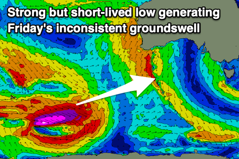
As touched on last week, a stream of east-southeast tracking frontal activity taking place to the south-west of Western Australia from yesterday through the coming days should generate some OK pulses of swell. The first and least consistent increase through Friday has already been generated by a polar low at the head of the frontal activity, with a fetch storm-force to hurricane-force W-W/NW winds generating a decent increase in size through Friday to 3ft+ across the Surf Coast magnets with 5-6ft sets to the east.
The secondary, more patchy and weaker activity looks to generate a secondary similar pulse for Saturday morning to 3ft+ on the Surf Coast and 4-6ft to the east, easing through the day.
Local winds unfortunately look to remain a problem with lingering troughy activity bringing freshening S/SE winds on Friday, likely improving Saturday with variable N/NE-E/NE winds, shifting SE into the afternoon.
This will favour the beaches over the reefs, though the size might be a bit of an issue.
Sunday looks better with N/NE offshores and easing surf from a fun 3ft to possibly 4ft, small Surf Coast.
Looking term we’ve got a good run of moderate sized W/SW groundswell under NW tending N’ly winds through the middle of next week but we’ll take a closer look at this in the coming updates.