Good run for the Surf Coast

Victorian Forecast by Craig Brokensha (issued Wednesday July 9th)
Best Days: Today, tomorrow morning Surf Coast, Friday morning Surf Coast, all weekend Surf Coast, Monday Surf Coast
Features of the Forecast (tl;dr)
- Easing mix of swells tomorrow, with an inconsistent W/SW groundswell for the PM, easing Fri
- Fresh W/NW-NW winds tomorrow, shifting stronger W/SW later morning and then W'ly after
- Strong W/NW-NW tending W/SW winds Fri
- Moderate sized mid-period W/SW swell for Sat, with a similar sized groundswell for later in the day/Sun AM, easing
- Fresh NW winds Sat
- Strong N/NW winds Sun
- Moderate sized mid-period W/SW swell for Mon AM with W/NW-NW winds
- Mod-large W/SW swells for mid-late next week
Recap
Yesterday was a lay day under strengthening northerly winds and with a small to tiny, leftover swell.
Today we’ve got a mix of mid-period W/SW swell energy and building W/SW groundswell with clean conditions on the Surf Coast and sets to 3ft to occasionally 4ft which should become a touch stronger/more consistent through the day as winds shift more N’ly later.

Good surf this morning
This week and weekend (Jul 10 - 13)
Today’s mix of swells is the pick of the week, with a drop in size and energy due through tomorrow morning back from the 3ft range on the Surf Coast, 4-5ft+ to the east as fresh, morning W/NW winds shift stronger W/SW later morning, possibly reverting back to the W’ly into the afternoon.
Swell wise, a reinforcing pulse of inconsistent W/SW groundswell is due into the afternoon tomorrow, easing Friday, generated by the earlier stages of a strong frontal system that projected up towards Western Australia through yesterday.
This should come in at 3ft+ to the west with 5-6ft sets to the east, easing through Friday morning from a similar size.
Conditions look clean for the Surf Coast with a strong W/NW-NW breeze, shifting W/SW into the afternoon as the next frontal system moves through.
Some new mid-period W/SW swell is due from this frontal system on Saturday, with less consistent groundswell due to follow very late Saturday but more so Sunday morning.
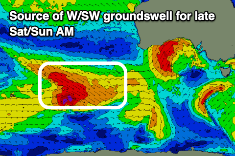
This front is currently north-east of the Heard Island region, with a great fetch of W/NW gales due to weaken once passing under the country tomorrow and Friday, generating two separate pulses of swell.
The mid-period swell for Saturday looks to come in at 3ft to occasionally 4ft on the Surf Coast and 6ft to the east, with the groundswell likely to be similar but a little less consistent, easing through the day Sunday.
Winds will be gusty out of the NW for most of Saturday, favouring the Surf Coast with strong N/NW winds through Sunday.
Another front passing through Sunday/Monday may generate a reinforcing pulse of mid-period W/SW swell for Monday morning as offshore winds persist for the Surf Coast, with increasing activity likely under the country through the rest of the week. This would bring building levels of moderate to large W/SW groundswell mid-late week under offshore winds, but we’ll look at this closer on Friday.