Smaller surf over the coming days, with a good groundswell for the weekend

Victorian Forecast by Craig Brokensha (issued Wednesday May 18th)
Best Days: Today Surf Coast, beaches to east layer tomorrow, Friday afternoon and Saturday afternoon, selected spots Sunday and Monday
Features of the Forecast (tl;dr)
- Easing W/SW swell tomorrow with N-N/NW winds, tending N-N/NE later to the east
- Small, inconsistent W/SW groundswell for later tomorrow but more so Friday/Saturday
- Moderate N-N/NW winds Fri/Sat, weaker N/NE to the east in the PM
- Moderate sized W/SW groundswell building Saturday afternoon, peaking early Sun, easing
- Strenthening N-N/NE winds Sun, similar N Mon
- Mod-large W/SW swell likely building into the middle of next week with strong W/NW winds
Recap
Yesterday’s expected, strong W/SW groundswell which looked better on paper than the previous from last week failed to really deliver again, with the large surf seen across Western Australia and South Australia, not materialising across the Victorian region.
Instead we saw broken up, lumpy and slow 3-4ft sets across the Surf Coast with larger waves to the east, increasing a little into the afternoon as localised mid-period swell built from the low moving through Bass Strait.
This morning is much better with the easing mid-period swell under better offshore winds with great 4ft waves across the Surf Coast, still average to the east and easing from 6ft on the sets.

Much better conditions and swell today
This week and next (Jun 19 - 27)
Looking at the rest of the week, and the current mid-period swell will continue to fade through today, bottoming out tomorrow morning with 2ft waves left on the Surf Coast, 3-4ft to the east.
A small, inconsistent, long-range W/SW groundswell may be seen later in the day, though Friday/Saturday are more reliable.
The source of these swells was a distant but strong Southern Ocean frontal progression across the Heard Island region, with slow 2ft sets due on the Surf Coast magnets, possibly 4ft to the east.
Winds look N/NW-N tomorrow morning, shifting more N-N/NE later to the east, with Friday/Saturday playing out similarly, though with lighter N/NE winds due into the afternoon to the east. This looks like the window to surf those exposed locations that being the afternoons Friday and Saturday.
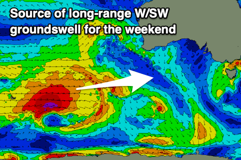
Now later in the day Saturday and more so Sunday morning, a stronger, long-range W/SW groundswell is due to fill in, generated by a great polar frontal progression that formed over the weekend and pushed across the Heard Island region earlier this week while generating fetches of gale to severe-gale W/SW winds.
Last night, the final stages of the progression still saw severe-gale W/SW winds being generated south-west of Western Australia, with a moderate sized groundswell due to result.
There should be signs of it into Saturday afternoon and this may cause a few issues size wise on the beaches to the east when winds improve (2-3ft Surf Coast and 4-5ft to the east), but Sunday morning looks to come in at good 3ft+ across on the Surf Coast (4ft sets likely) with 6ft sets to the east.

Strengthening N/NE winds are still due through the day, more N’ly in the morning with strong N’ly winds set to continue Monday as the swell eases.
Into next week, further pulses of long-range W/SW groundswell are due but we’ve got some closer-range developments due early-mid next week, with a strong mid-latitude frontal progression due to dip south-east across us through Monday/Tuesday.
At this stage it looks like we could see moderate to large levels of W/SW swell, especially into Wednesday but check back here Friday for an update on the timings, sizes and local winds.