Great period ahead with increasing westerly swell energy

Victorian Forecast by Craig Brokensha (issued Wednesday May 11th)
Best Days: Today, tomorrow morning, Friday, Saturday, Tuesday Surf Coast
Features of the Forecast (tl;dr)
- Easing SW groundswell tomorrow with N/NW-NW winds, lighter into the PM
- Inconsistent, moderate + sized W/SW groundswell building later tomorrow, peaking Fri AM, easing with N/NW-NW tending variable N/NE winds
- Easing surf Sat with strengthening local offshore winds (N/NW to the west, N/NE to the east)
- Small Sun with strong N/NE-N tending N/NW winds
- Small mix of swells Mon with strong N winds
- Large W/SW swell Tue with strong NW tending W/NW winds
Recap
Conditions improved across the Surf Coast yesterday with a peaky mix of S/SE windswell and smaller S/SW swell, coming in at 3ft through the morning before easing through the day. To the east the morning offered light winds and improving conditions before onshore winds kicked in after lunch.
Today a new, inconsistent SW groundswell is in the water but the size isn’t overly impressive with sets to 3ft on the Surf Coast again (under the expected 4ft), 4-5ft to the east under a light north-west breeze.

New swell this morning
This week and next (Jun 12 - 20)
Today’s inconsistent SW groundswell is due to start easing into tomorrow and conditions will be best for locations west of Melbourne with a N/NW-NW offshore, becoming lighter through the afternoon.
The Surf Coast should ease back from 2ft to occasionally 3ft with 4ft+ sets to the east.

Later in the day, we may see the forerunners of a new W/SW groundswell filling in, though the peak is due through Friday morning.
The source of this swell was a strong mid-latitude low that formed west-southwest of Western Australia over the weekend, projecting a great, slow moving fetch of severe-gale W/SW winds through our medium to long-range swell window.
The swell will come in quite west in nature resulting in a loss in size and consistency across the Surf Coast but we should see 4ft waves across the magnets through the morning with 6ft waves to the east, while the odd bigger one is likely at times but very infrequent.
Expect an easing trend through the day and winds look light to moderate N/NW-NW through the morning, tending variable N/NE into the afternoon. This will create improving conditions to the east after lunch, smaller Saturday under freshening, local offshore winds (N/NW to the west and N/NE to the east).
Easing 2-3ft sets are due on the Surf Coast magnets Saturday morning with 4-5ft waves to the east.
Sunday looks a bit smaller with stronger N/NE-N tending N/NW winds.
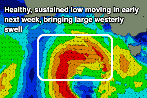
Into later Sunday and Monday, some tricky and small W/SW energy is due, but later in the day and more so Tuesday, a larger W/SW groundswell is on the cards. This will be generated a great, slow moving mid-latitude low moving in from the South West of Western Australia, pushing right over towards us through the weekend and Monday.
Fetches of strong to gale-force winds should generate a large W/SW groundswell for Tuesday morning to what looks to be an easy 6ft on the Surf Coast and 8ft+ to the east under strong NW tending W/NW winds.
Wednesday looks great as well with easing levels of swell under N/NW winds.
Longer term the outlook remains active with plenty of westerly swell due from late in the week into the following week thanks to an increase in Southern Ocean frontal activity south-west of Western Australia. More on this Friday.
Comments
Very promising after a few days rest. Feels like bask to normal winter pattern
Gday Craig, is there any change to the forecast for tomorrow or is everything still looking, as above?
we have to weigh up the W direction scales of justice. how many times has the forcast said clearly W in direction and yet we all still get sucked in to shifting our schedual around hope. me included.
The forerunners have hit the Cape Sorell buoy, with the peak due through the day. I'd say very inconsistent but hopefully on track. Cape du Couedic didn't kick as hard as I had thought it would though..
Thanks Craig for taking the time to make comment.
Looks to have come in under-sized again, lovely 3ft sets but not to what I was expecting unfortunately.