More options opening up for the weekend

Victorian Forecast by Craig Brokensha (issued Friday May 30th)
Best Days: Tomorrow, Sunday, Thursday on the beaches
Features of the Forecast (tl;dr)
- Moderate sized S/SW groundswell for tomorrow AM, easing, smaller Sun
- Light-mod W/NW winds tomorrow AM (N/NW-NW across PI), with variable, weak sea breezes
- Moderate N winds Sun, N/NW for a period in the AM to the west, N/NE to the east into the PM
- Inconsistent, small SW groundswell Mon with moderate N-N/NW winds
- Easing surf Tue with W/NW tending strong S/SW winds later AM
- Fresh S/SW winds Wed
- Small-mod sized mid-period S/SW swell for Wed PM and Thu AM, easing
- Freshening N/NE winds Thu, stronger N Fri
Recap
Fresh onshore winds continued to create poor conditions yesterday, persisting across eastern locations this morning, but over to the west, there’s been a slight reprieve in the winds with a lighter W’ly breeze offering cleaner conditions along with 3ft sets.
This weekend and next week (May 31 - Jun 6)
As discussed throughout the week, the weekend looks much better for surfing across all locations with winds due to improve tomorrow but be best Sunday to the east.
A W/NW breeze will again favour the Surf Coast tomorrow morning, with pockets of NW-N/NW winds due around Phillip Island, and sea breezes look weak if not variable, creating decent conditions for most of the day.
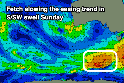
Swell wise, our good pulse of S/SW groundswell for the morning is on track, generated by a fetch of gale to severe-gale SW winds to the south-west of Tasmania yesterday afternoon and evening. This fetch is now east of Tasmania and out of our swell window, but, a trailing fetch of weaker W/SW winds should help slow the easing trend into Sunday.
Surf to 4ft+ is due on the Surf Coast tomorrow morning with 6ft sets to the east, with Sunday easing from 3ft west of Melbourne and 4ft+ to the east.
Winds will shift more N’ly on Sunday, with a period of N/NW breezes due through the morning on the Surf Coast, tending N/NE to the east into the afternoon.
On Monday, the wind looks to have a more N-N/NW bias all day and we should see an inconsistent, long-range SW groundswell in the mix, generated way over in our far swell window, to the south and south-east of South Africa early this week. The Surf Coast should see slow 2ft sets, 3-4ft or so to the east.
Make the most of this little run of offshores, as come Tuesday, early W/NW winds will shift strong S/SW later morning, creating deteriorating conditions. The surf will also be small and slow, not worth traveling far for the early, with Wednesday seeing fresh S/SW winds persisting across the region.
The weak frontal system attached to this change should produce a small lift in mid-period S/SW swell for Wednesday afternoon and Thursday morning, and winds look to quickly swing back to the N/NE while freshening, making it worth penciling in a surf day.
The Surf Coast only looks to offer 2-3ft waves, with 4ft+ sets to the east, easing into the afternoon Thursday with much smaller waves Friday under strong N’ly winds. This abrupt swing in the winds is thanks to mid-latitude low moving in from the west but it looks to north in latitude to generate any decent size.
Otherwise some very inconsistent long-range SW groundswell looks to fill in next weekend, with better swell possibilities into the following week. More on this Monday, have a great weekend!
Comments
Sat-Sunday Djarrak / Bells Beach https://australianindigenoussurfingtitles.com/
Big high tide this arvo and someone got stranded
https://www.abc.net.au/news/2025-06-01/man-winched-to-safety-cliff-jan-j...