Plenty of swell with tricky winds thanks to troughy weather

Victorian forecast by Craig Brokensha (issued Friday April 18th)
Best Days: Today, tomorrow working the winds, Thursday, Friday morning
Features of the Forecast (tl;dr)
- Small-mod sized, reinforcing W/SW swell tomorrow AM, easing, smaller Sun
- Early, variable light local offshore winds tomorrow, tending E-E/NE then SE ahead of a late NW change
- Pre-dawn, fresh N/NE winds Sun, tending N/NW then W/NW through the AM, then variable later
- Strengthening S/SW winds Mon
- Moderate sized mix of SW groundswells building Tue PM, peaking Wed AM, easing slowly therafter
- Strong S/SE-SE winds Tue, fresh to strong E/SE-SE Wed
- SE windswell in the mix Mon PM through Wed
- Easing swells Thu with fresh N/NE winds
- Smaller Fri with N/NW tending S/SW winds into the mid-PM
Recap
The underperforming SW groundswell due into Wednesday actually kicked nicely into the afternoon with 3ft sets on the Surf Coast and 4-5ft waves to the east, with the swell dropping temporarily into yesterday morning under light, local offshore winds.
The beaches were the pick and good before new levels of W/SW swell started to arrive, building towards the 5ft+ range on the exposed beaches to the east with 3ft sets on the Surf Coast with workable E’ly winds.
Today the W/SW swell has peaked with 3-4ft sets on the Surf Coast magnets and strong 6ft waves to the east with great conditions on the beaches but a touch too much size. Conditions will remain favourable until a strong S/SW change moves through mid-afternoon.
This weekend and next week (Apr 19 - 25)
Today’s W/SW swell will start to ease back through tomorrow, though slowed by the arrival of a reinforcing mid-period W/SW swell, generated by a small frontal system that slid south-west of Western Australia mid-week.
The Surf Coast should still be in the 3ft range (rare bigger one magnets) with 5ft+ sets to the east, easing slowly through the day and smaller into Sunday.
It should also be noted that there’ll be some small, inconsistent E’ly groundswell from Ex-TC Tam in the Tasman Sea this afternoon and tomorrow morning, most visible from about Lorne south.
Winds tomorrow will be variable and likely light, local offshore on the Surf Coast early before tending more E-E/NE and possibly SE ahead of a late NW change. This funky outlook is thanks to a small surface low meandering in from the west, with it due to bring pre-dawn, fresh N/NE winds Sunday, shifting N/NW shortly after dawn and then W/NW mid-morning before then going variable into the afternoon.
With this outlook there should be options across both regions through the day, though keeping on top of the shifts will be key.
The low will weaken and move east as a trough on Monday bringing fresh S/SW tending stronger S/SW winds Monday, writing off the surf for the day.
Tuesday also looks like a lay day with strong S/SE-SE winds as high pressure slides in and under the state, swinging E/SE-SE on Wednesday but remaining fresh and gusty.
This will kick up poor levels of SE windswell on the Surf Coast, while a distant, long-range SW groundswell is due to the east into Tuesday afternoon but more so Wednesday.
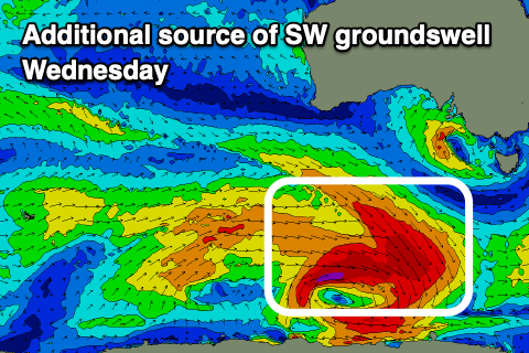
As touched on earlier in the week, the source of this swell was a strong but distant frontal progression that started south of South Africa and travelled east towards the Heard Island region the last couple of days. Multiple fetches of severe-galeforce winds should produce an inconsistent but moderate sized SW groundswell for later Tuesday, peaking Wednesday morning.
An additional, closer-range and more consistent SW swell is due to be in the mix Wednesday, generated by great, pre-frontal gale to severe-gale NW winds moving under the country on the weekend, with tighter severe-gale to storm-force W winds immediately following around the core of the low.
The Surf Coast is due to come in around the 4ft range with 6ft surf to the east but with those poor winds, easing Thursday under gusty, persistent N/NE winds.
Friday will be smaller again with a N/NW offshore ahead of a S’ly change mid-late afternoon.
Looking at next weekend and beyond, and it’s not overly special with S’ly winds expected in the wake of Friday’s trough along with moderate + levels of swell.
We may see winds persist from the south-eastern quadrant into early next week depending on another possible Tasman Low forming, but more on this Monday. Have a great weekend!
Comments
Feels like the Bells event is doomed lately... The last few years we've had plenty of swell and good conditions in the weeks before and after the window, with leftovers while it runs. Doesn't look like changing this year.
It's called Karma.