Flukey outlook best suited to the beaches

Victorian forecast by Craig Brokensha (issued Wednesday April 16th)
Best Days: Beaches tomorrow, Friday ahead of the afternoon change, Saturday, Wednesday morning, Thursday morning
Features of the Forecast (tl;dr)
- Small, inconsistent SW groundswell tomorrow, with a better W/SW swell arriving later
- Moderate sized but inconsistent W/SW swell for Fri, easing slowly Sat
- E/NE winds tomorrow, with possible late sea breezes
- N/NE winds Fri, tending N/NW during the day to the west ahead of a strong S/SW change mid-PM
- N-N/NE winds Sat, possibly freshening from the N/NW into the PM
- Smaller Sun with strengthening W/NW tending W/SW winds
- Poor mix of swells Mon with strong SW tending S/SW winds
- Average mix of swells Tue with fresh S-S/SE winds
- Very Iinconsistent, moderate sized SW groundswell building later Tue, peaking Wed with N/NE winds ahead of a shallow S change
- Easing swell Thu with N/NW winds
Recap
Conditions were average on the Surf Coast yesterday with a mix of SE windswell and SW swell to 2-3ft, with improving conditions to the east as early east winds shifted more offshore. Sets easing back from the 4ft range.
Today, our S/SW groundswell spreading radially off a poorly aligned fetch of W/NW gales looks to have come in undercooked. The Surf Coast is a slow 2ft to sometimes 3ft with 3ft to occasionally 4ft under great offshore winds.
This week and next (Apr 17 - 25)
Today’s pulse of tricky SW groundswell was expected to be the best of two, with the secondary pulse due into tomorrow. This secondary pulse was generated by an even less favourably aligned fetch of NW gales and now looks to only maintain slow 2ft sets on the Surf Coast with 3ft+ waves to the east.
Into the late afternoon however we should start to see some new W/SW swell arriving, generated by the strong polar frontal progression that projected up and then under Western Australia earlier this week, weakening yesterday.

The bulk of the swell is due on Friday but we may see sets pushing 2ft+ on the Surf Coast later tomorrow with 4ft+ waves to the east, peaking in the 3ft to occasionally 4ft range on the Surf Coast magnets Friday with 5-6ft sets to the east.
Conditions will be clean on the beaches again tomorrow with an E/NE breeze, with possible late arriving sea breezes (if any), with Friday morning looking favourable to the east again with a N/NE offshore, while to the west, a N-N/NW wind will develop through the morning before a trough brings a strong S/SW change mid-afternoon.
The trough will be temporary and weak, with winds due to revert back to the N-N/NE on Saturday morning along with a smaller, reinforcing W/SW swell. This is being generated by a small fetch of strong to gale-force W/NW winds currently south-west of Western Australia, with the Surf Coast expected to ease from a slow 3ft with 4-5ft sets to the east.
Winds may tend N/NW and freshen into the afternoon Saturday but we’ll review this on Friday, with Sunday coming in smaller under strengthening W/NW tending W/SW winds.
This shift in wind will be ahead of an approaching trough which will move through Monday, bringing strong SW tending S/SW winds, easing through the day.
No quality swell is due to arrive with this trough, with local windswell being more dominant into the afternoon and Tuesday as winds remain poor and fresh from the S-S/SE.
Into the late afternoon Tuesday but more so Wednesday, a new, long-range and inconsistent SW groundswell is due, generated by a strong, mutli-staged low that’s formed to the south of South Africa.
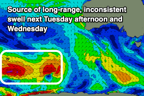
An initial fetch of very distant, gale to severe-gales has now weakened, but a secondary polar front pushing up over the back of the initial low today is generating an additional fetch of gale to severe-gale W/NW winds that will project to about the Heard Island region tomorrow before weakening into the afternoon.
This will generate a very inconsistent SW groundswell that should come in at 3ft on the Surf Coast and 4-5ft+ to the east. Local winds should swing back around to the N/NE on Wednesday ahead of a shallow S’ly change into the afternoon, N/NW on Thursday as the swell eases.
Longer term there’s still nothing too major on the cards until possibly next weekend when a strong frontal system pushes up and over us, but local winds and conditions look iffy. More on this Friday.