Great weekend of surf

Victorian Surf Forecast by Craig Brokensha (issued Friday March 8th)
Best Days: Today ahead of sea breezes, Saturday, Sunday, Monday, Thursday morning
Features of the Forecast (tl;dr)
- Slowly easing swell tomorrow with N/NE winds, freshening during the day and tending N at times (likely N/NW-N into the PM to the west)
- Smaller Sun with fresh N/NE winds, tending S'ly to the west through the PM
- Moderate sized W/SW-SW groundswell for later Sun, peaking Mon AM, easing steadily with local offshore winds, holding most of the day
- Easing swell Tue with strong but easing S winds
- Moderate + sized SW groundswell Wed with S/SW winds, easing Thu with variable morning winds
Recap
The surf was small and bumpy across all locations yesterday morning, building through the afternoon but with freshening southerly winds. Today our better pulse of mid-period W/SW swell has filled in with 3-4ft waves on the Surf Coast and 5-6ft sets to the east but with bumpy conditions to the west, cleaner to the east.
Winds are due to shift E/NE-NE through the morning, creating cleaner conditions across all locations before S/SE-SE sea breezes kick in through the afternoon.
This weekend and next week (Mar 9 -15)
Today's W/SW swell energy will have a bit of longevity to it, thanks to the progression that generated being two staged elongated.
This should maintain 3ft sets across the Surf Coast into tomorrow morning, 4-5ft to the east, with great N/NE winds, freshening through the day and tending N'ly at times to the east and N/NW-NW to the west during the day, back to the N/NE later.
This will create a full day of great surf on the beaches.
Sunday looks smaller and conditions windy but clean to the east, gusty from the N/NE most of the day ahead of an evening S'ly change as a trough moves in from the east. The Surf Coast will see the change arriving early, more into the early-mid afternoon but initially weak.
Size wise, the Surf Coast will be smaller and to 2ft, with 3-4ft sets to the east.
Now, later in the day, some new W/SW groundswell is due to arrive, ahead of the pulse of the energy Monday. The source of this swell is a rapidly deepening mid-latitude low under the country this evening and early tomorrow.
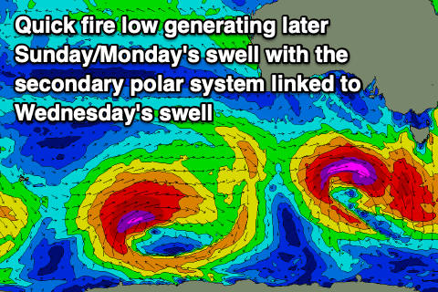
A tight and fast moving fetch of severe-gale to storm-force winds (at its core) are due to be projected through our western and then south-western swell windows, generating a short-lived pulse of groundswell.
The peak looks to be overnight Sunday but Monday should pulse to 3-4ft on the Surf Coast, 6ft to the east, easing quickly through the day.
Winds look great for both locations and N/NW to the west, N/NE to the east, and holding most of the day.
These favourable winds will be ahead of a trough which is due to move in at dawn Tuesday, bringing strong S'ly winds, easing through the day as Monday's swell continues to ease.
Our secondary pulse of SW groundswell for Wednesday is on track, but so are persistent S/SW winds, with Thursday looking a possibility of cleaner conditions as the trough moving through Tuesday stalls to our east.
Coming back to the swell, and a slow moving polar low forming just east of the Heard Island region today should generate a moderate + sized pulse of groundswell energy that should come in at 4-5ft on the Surf Coast and 6-8ft to the east, easing back from 3-4ft and 5-6ft respectively Thursday. We'll have a clearer idea on the local winds and conditions Monday though so check back then for an update. Have a great weekend!
Comments
Epic - can't wait ... thanks Craig!
Combine that with high 30 degree temps for the weekend and cue the biggest crowds of the summer ... Let's spread out everyone.
Fingers crossed the slightly punchier size Saturday and Monday keeps the crowd down a bit or at least spread out at the exposed spots.
You're dreaming lol
A man can dream!
Craig any reason why the water is so cloudy down here? I thought is was the big swells we are having lately however it usually settles it is a real green colour.
Interesting, it usually goes that greenish colour after an upwelling event, when the nutrient rich water hits sunlight and photosynthesis occurs. Did it cool off recently?
A little a degree or so prior to that is was unusually warm like 21+ maybe that was it
Amazing long weekend forecast, murphy's law as i cant surf due to snapping my ACL. Any other time it would be onshore garbage.
Hope everyone gets some - should be heaps of options - hit up your favourite beachie.
Out of interest Is there a reason Craig why models are showing Westerly winds into southerly’s by midday Sunday ?
Yeah a funky trough sitting across Bass Strait that looks to influence the Surf Coast more than locations to the east.
Any chance of those cooler winds hitting the Supernatural Amphitheater at Meredith?
I’ll be sweating it out at Golden Plains festival.
How'd ya go, cooked?!
Ha yeah it was pretty damn hot (but manageable).
Missed a pumping long weekend of waves.
looks like we're in for the usual pumping swell that arrives 2 weeks before bells.
Fingers crossed.
PS a bit bigger than 3ft today. Good swell, crap wind
Anyone know whats up with all the crickets?
Warm night?
When boiling and egg is it 2min or 3min I'm confused..... noting I would like it runny in the middle
3 mins but add an extra minute for every 100m above sea level
How's the run of waves been, and it continues today. Sore bodies?
Nah, we train for this Craigoss.
Ha!
I for one am rooted. Ed may train, I drink beer.
Dunno if it's just me growing older and grumpier but it seems there are far more one wave sets these days. Highly frustrating in a crowded lineup.
The bank I lucked into on Saturday morning felt almost as good as it gets on the exposed beaches - solid 2.5hr with only 5 of us.
Absolutely maxing on the beaches today, couldn’t find anything remotely close to holding the size on the outside.
What coast are you on?