Large swell for the weekend with average but improving winds

Victorian Surf Forecast by Craig Brokensha (issued Wednesday February 7th)
Best Days: Sunday morning, Monday exposed beaches, Tuesday selected beaches
Features of the Forecast (tl;dr)
- Small mid-period SW swell tomorrow with moderate S/SE winds, freshening
- Easing swell Fri with gusty S winds
- Large S/SW groundswell filling in Sat, peaking through the PM with gusty, easing S/SE-SE winds, strengthening again into the PM
- Steadily easing S/SW swell Sun with variable winds tending SE on the Surf Coast, N/NE-NE to the east ahead of sea breezes
- Small Mon, with a late pulse of small-mod sized S/SW groundswell with strengthening N/NE winds
- Easing swell Tue with strong N winds, easing later
Recap
Average surf yesterday with easing swell and onshore winds, a little cleaner this morning but smaller and weak, only doable for the desperate on the Surf Coast.
This week and weekend (Feb 8 - 11)
Forget the end of the week as S/SE winds will create bumpy conditions tomorrow with a minimal increase in weak swell, S'ly on Friday as the swell fades.
We then look to the weekend and our large pulse of S/SW groundswell that's due to fill in on Saturday.
On Monday the models diverged regarding the strength of the polar low forming to the south-west of us over the coming days, but EC has come to the party and we're looking at a beefy swell producer.
The catalyst for the low will be the remnants of another tropical low in the Indian Ocean, drifting south-east into the westerly storm track, deepening significantly south-west of us.
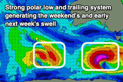
A fetch of severe-gale to storm-force W/SW-SW winds will be generated through our southern swell window tomorrow, pushing further east and under Tasmania through Friday.
A large, powerful S/SW groundswell will result, arriving around dawn Saturday and pulsing strongly to 8ft range on the Surf Coast magnets through the day, 8-10ft to the east but with gusty, easing S/SE-SE winds, strengthening again into the afternoon as a small surface trough slips in from the east.
This trough will continue across us on Sunday, swinging winds to the N/NE across locations east of Melbourne and variable on the Surf Coast during the morning before SE sea breezes kick in. There'll be SE windswell in the mix Sunday morning along with the easing S/SW groundswell which will drop steadily from the 4ft+ range early on the Surf Coast, 5-6ft to the east.
While not great this will be the window to surf on the Surf Coast.
A temporary low point in swell is due Monday morning back to 2ft max on the Surf Coast magnets and 3ft to the east but conditions look favourable for the exposed beaches with a persistent N/NE breeze.
Later in the day some new S/SW swell is expected to arrive, generated by a pre-frontal fetch of strong to near gale-force W/NW winds following the polar low. A kick to 2-3ft is due on the Surf Coast but likely on dark, 4ft+ to the east, easing back from a similar if not slightly smaller size Tuesday.
Strong N/NE-N winds will create tricky but favourable conditions across selected spots Tuesday, easing later ahead of a strong, evening SW change that will then spoil the surf into Wednesday.
Some new, mid-period SW swell from the frontal system bringing the change is due into Thursday but with what looks to be S winds. More on this Friday.
Comments
Hey Craig,
I was just wondering how accurate the Wilson’s prom forecast is on here. Never been to that stretch and it’s saying 2-3ft Sunday looking forward to exploring around.
Cheers
Hey Nick, looking at the forecast I reckon 2-3 ft is unders. The islands off the prom block a bit of swell, but not that much. Squeaky is such a great wave but if too big you can surf Norman beach (bit softer wave) or if thats too big you can walk to Oberon bay. All the beaches can have waves on the way in ie Whiskey etc. Winds look great for the Prom hope you score.
Sorry Nick, missed the above. Swell is quite south on Sunday and easing quick so Tassie will likely block a lot of it. 2-3ft might be about right. Let us know how you go.
And thanks euchat.
Legends thanks Euchat and Craig will report back, excited to see what it’s like squeaky and Norman beach look like fun.
Cheers
SAM looking to return to neutral next week, good news for winds! And my tomatoes!
My rents are growing tomatoes too down in the bay. Curious how the “SAM” you mentioned above affects them. Keen to pass on the info
Honestly. Has Celsius gauge been recalibrated? I can’t remember the sun having so much bite considering what temp they forecast. Not to mention the peak of heat being in the mid/late arvo as opposed to earlier in the day.
“21.2 °C Now - Feels Like 18.1 °C”
Get fucked. Especially if you’re in that sun.
I was outside most of the day today. Top temp according to BOM was 22.5. Definitely felt a few degrees warmer - and that was with a pretty stiff onshore.