Decent surf over the coming days

Victorian Surf Forecast by Craig Brokensha (issued Wednesday January 17th)
Best Days: Protected spots tomorrow and Friday morning, beaches Saturday morning
Features of the Forecast (tl;dr)
- Moderate sized W/SW-SW swell tomorrow morning with a larger S/SW swell building later in the day, peaking Fri AM and then easing
- Strengthening W/NW winds tomorrow, tending W-W/SW late
- Moderate W/NW-W winds Fri AM, freshening and tending S/SW late AM
- Rapdily easing S'ly swell Sat with E/NE tending fresh SE winds
- Small background SW swell Sun with fresh S/SE tending strong S winds
- Small Mon with strong S winds
- Small SE windswell Tue with strong E/NE tending N/NE then E/SE winds
Recap
Fun waves across the beaches yesterday both west and east of Melbourne with a mix of easing SE windswell and background S/SW swell to 2-3ft on the Mornington Peninsula and 2ft+ on the Surf Coast.
Winds remained favourable all day as the swell faded into the afternoon, small to tiny this morning with N'ly winds ahead of a bit of weather and change as a mid-latitude low moves in from the west.

Mid-latitude moving in this morning as the sun rises across the country
This week and next (18 - 26)
The interaction between a mid-latitude low moving in from the west and polar front projecting up from the south-west yesterday is now resulting in the deepening of the low to our south-west today as it stalls.
This will be the main source of swell over the coming days, with it due to project a slow moving fetch of strong SW-S/SW winds through our south-western and then southern swell windows.
The swell from the low should be in the water tomorrow morning but the bulk of the size is due later in the day and into the evening, peaking early Friday morning but then on the ease.
There'll also be some mid-period swell from the polar front in the mix tomorrow but the localised swell will more than likely overshadow it.
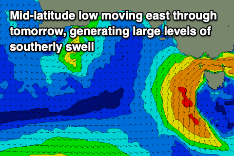
Size wise, the Surf Coast looks to be in the 4ft range on the magnets tomorrow morning, 3-4ft across other breaks with 6ft sets to the east. The swell should build further to the 6ft range later in the day on the Surf Coast, then ease from 6ft+ Friday morning with 8ft+ waves to the east.
Local winds look best for protected spots tomorrow, favourable most of the day and strengthening from the W/NW, shifting W'ly into the evening and possibly W/SW later in the day.
Friday morning should provide a window to the west with a moderate W/NW-W breeze, though winds are due to shift S/SW later morning and freshen so get in before then.
Moving into the weekend, the swell will ease off quite rapidly thanks to it being locally generated, and the source being cut off as the low moves east across Tasmania Friday.
The swell will swing more south in direction as well, with easing sets from 2-3ft on the Surf Coast, 3ft+ to the east. Winds should improve for locations to the east with a morning E/NE breeze ahead of fresh SE sea breezes.
Sunday looks small and onshore with a trough due to bring fresh and strengthening S/SE tending S winds.
Unfortunately the outlook for next week isn't great, with the trough moving through Sunday expected to deepen across our region, bringing strengthening E winds and some localised SE windswell.
The mid-latitude activity will prevent any other major swell generating activity firing up in the Southern Ocean so with this in mind make the most of the coming days.
Comments
Gotta admit I was pretty sceptical about this prediction on Monday with the position of the low being so high up.
But seeing is believing.
Well done Craig
Thanks RR.
So with the recent controversy about the surf cams at Torquay, the perfect response was to put another one up lol
Torquay North and Jan Juc!
Good to feel some energy in the water today. Finally
Nice to see some size out there in the not-SE blustery wind today!
Satellite pic looks beautiful
Easy 8ft sets on dark, plenty of energy and not many crew on it
Nice!!