Strong swell tomorrow, cleanest as it eases Wednesday

Victorian Surf Forecast by Craig Brokensha (issued Monday 11th December)
Best Days: Wednesday, Thursday ahead of the late change Surf Coast, Friday morning Surf Coast, Monday morning on the beaches
Features of the Forecast (tl;dr)
- Mod-large SW groundswell peaking through the day tomorrow with E/SE tending fresh SE winds (lighter E for a period in the AM)
- Easing swell Wed with NE winds, tending N for a period during the day
- Smaller Thu AM, with a new S/SW groundswell building into the mid-late PM with fresh W/NW winds ahead of a late SW change
- Easing surf Fri with W/NW tending S/SW winds
- Small mid-period SW swell Sat/Sun with light NW tending SW winds Sat, W/NW tending SW winds Sun
- Moderate sized mid-period W/SW swell building Mon, peaking Tue
- E/NE tending SE winds Mon, gusty S/SE winds Tue
Recap
A generally poor weekend of surf with average winds and swells that only suited to the desperate.
Today conditions are even worse through Bass Strait thanks to a strong S/SE breeze, whipping up a localised S/SE windswell on the Surf Coast with some background mid-period SW swell to the east.
This week and weekend (Dec 12 - 17)
The current synoptic setup sees a broad, strong low pressure system sitting across the Adelaide region, with high pressure to the south, setting up the current south-east pressure gradient across our state.
Over the coming days we're expected to see the low slowly weaken as the high moves east and this will see winds ease and swing more east-southeast tomorrow morning, shifting more favourably to the north-east on Wednesday as the low moves slowly across us.
Winds may temporarily tend more N-N/NW during the day on Wednesday but then revert back to the NE through the afternoon.
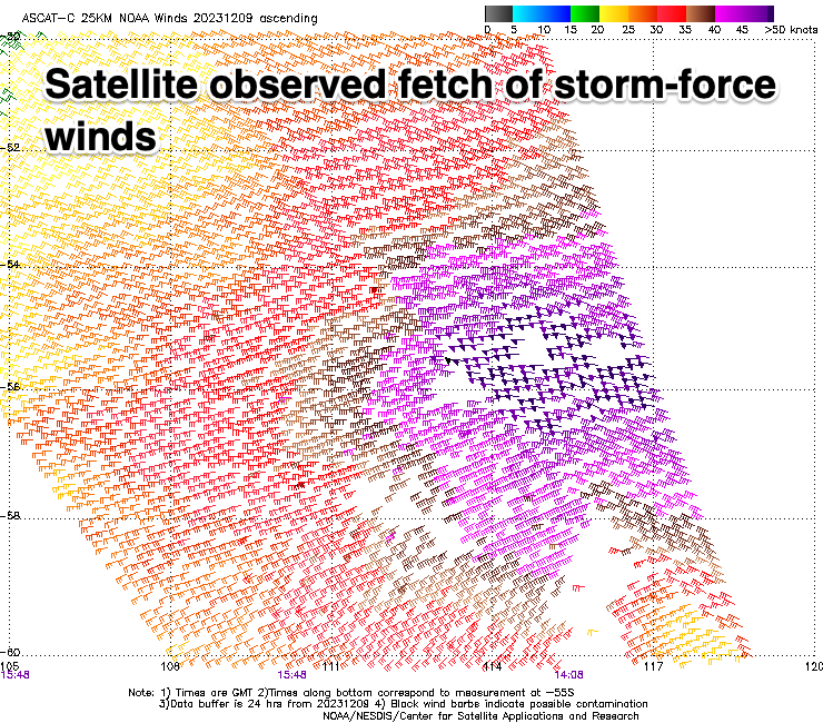
Swell wise, we've got our moderate-large, strong S/SW groundswell due tomorrow across the state, generated by a strong storm that fired up to the south-west of Western Australia late last week. This low generated a fetch of severe-gale W/NW tending W winds while pushing east through our south-western swell window and is now weakening while passing under Tasmania. There were even a few storm-force barbs registered by satellite (below left) and this should see a strong spike in size through the day across both coasts.
The Surf Coast is due to reach 5-6ft on the magnets, 6-8ft to the east, with the swell easing fairly steadily into Wednesday from the 4ft range on the Surf Coast, 5-6ft to the east.
As touched on above, winds tomorrow won't be ideal especially with the size of the swell, lighter E for a period to the east in the morning ahead of fresh SE sea breezes, but Wednesday looks fun as the swell eases through the day.
Winds are due to shift W/NW on Thursday and then SW later as the backside of the low moves through, but with smaller, fading surf from earlier in the week. During the day a new pulse of reinforcing mid-period S/SW swell is due, produced by a small, tight but strong low forming on the tail of the system linked to tomorrow's swell. This should boost the Surf Coast to 3ft during the late afternoon, 4-5ft to the east, easing Friday with a period of W/NW winds likely before tending S/SW.
Looking at the weekend, and apart from some small, mid-period SW swell on Saturday with morning NW winds, some better W/SW energy is due early next week, generated by a slow moving, healthy front passing under the country late week and into the weekend.
The only issue are the local winds, with a trough due to bring a S/SE change for Tuesday when the swell peaks, cleaner Monday morning ahead of the bulk of the energy.
We'll have a closer look at this on Wednesday.
Comments
It's hard to believe the surf may actually be ok in the coming days...its been so average for what feels like so long!