Poor weekend, improving surf Wednesday with an easing S/SW groundswell

Victorian Surf Forecast by Craig Brokensha (issued Friday 8th December)
Best Days: Today, Wednesday morning, Thursday morning Surf Coast
Features of the Forecast (tl;dr)
- Easing W/SW swell on the weekend with gusty S/SW winds
- Smaller Sun with moderate S/SE winds, strengthening from the SE during the PM
- Strong but easing SE winds later Mon
- Moderate sized SE windswell building late Sun, easing Mon
- Mod-large S/SW groundswell building Tue, peaking later, easing Wed and Thu
- Moderate E/SE-SE winds, freshening Tue
- Light-mod E/NE-NE winds Wed AM, with mid-late PM sea breezes
- Gusty W/NW tending SW winds Thu
Recap
Wednesday's inconsistent, building W/SW groundswell was replaced by some better, though still inconsistent mid-period W/SW swell yesterday, 3ft on the Surf Coast magnets and 4-5ft to the east with favourable morning conditions which persisted into the afternoon across selected spots.
This morning the swell is still there though more 4ft to the east, and will ease through the day as winds strengthen from the N/NE, shifting N/NW late afternoon on the Surf Coast ahead of an evening SW change.

Freshening offshore winds on the beaches
This weekend and next week (Dec 9 - 15)
As touched on in Wednesday's notes, this evening's change will be shallow, easing for a few hours before a more robust S/SW change moves in around dawn tomorrow, bringing fresh and gusty winds that will persist all day. Swell wise, the current swell will continue to ease leaving nowhere to surf.
Winds are due to shift S/SE into Sunday morning and ease a little though still be moderate, strengthening from the SE into the afternoon and evening as a deepening inland low across South Australia drifts south, squeezing a strong high pressure system sitting under Western Australia.
As the low stalls in the Bight Monday, strong SE winds will continue, likely easing later in the day, and with this we'll see some localised, moderate sized SE windswell from Sunday evening, start easing through the day Monday.
Winds look to ease further and start improving on Tuesday, tending moderate E/SE-SE through the morning, but Wednesday looks the best chance to get a cleaner wave with E/NE-NE winds as the low in the Bight weakens and the high moves east, under us.
Swell wise, our SW groundswell for Tuesday/Wednesday is on track with an upgrade in the expected size.
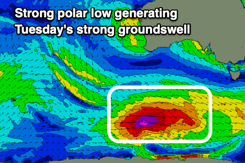
The source is a strong, deepening polar low to the south-west of Western Australia today, with a fetch of severe-gale W/NW tending W winds projecting east on the weekend, and then east-northeast under Tasmania Monday.
A moderate-large SW groundswell is due, building through Tuesday, peaking later in the day, easing Wednesday.
The Surf Coast should reach 5-6ft on the sets across the magnets, easing from 4ft+ on Wednesday morning, with 6-8ft sets to the east later Tuesday, easing from 6ft on Wednesday.
The surf is due to continue easing steadily into Thursday and winds are a little tricky with a trough Wednesday afternoon/evening, possibly being followed by a W/NW-SW change Thursday. Following this the outlook is a little hazy but we might see another strong groundswell the following week. More on this Monday, have a great weekend!