Improving surf on the weekend as the swell slowly eases

Victorian Surf Forecast by Craig Brokensha (issued Friday 1st September)
Best Days: This afternoon Surf Coast keen surfers, tomorrow morning, Sunday on the beaches, Tuesday to the west, Wednesday, Thursday to the west
Features of the Forecast (tl;dr)
- Moderate sized + mid-period W/SW-SW swell today with fresh but abating S/SW winds
- Less consistent, slightly smaller but stronger W/SW-SW swell tomorrow, easing Sun
- Light, local offshore winds tomorrow AM (N/NW Surf Coast, E/NE-NE to the east) ahead of E/SE-SE sea breezes
- Small, fading swell with strengthening N/NE tending NW winds
- Moderate sized, inconsistent W/SW groundswell building Tue, peaking into the mid-late PM
- Gusty W/NW tending W/SW winds Tue
- Moderate sized mid-period W/SW swell for Wed AM, easing
- Strengthening N winds Wed
- Easing surf Thu with strong NW tending W/NW winds
Recap
A low point in swell was seen yesterday morning with clean, 2ft+ waves across protected spots on the Surf Coast, poor to the east, giving into a midday, onshore change.
Today conditions are poor with a fresh SW breeze persisting in the wake of yesterday's change but with a good pulse of size coming in at 4ft on the Surf Coast magnets and 6ft+ to the east. Winds will slowly abate all day, creating improving conditions into the afternoon for the keen.
This weekend and next week (Sep 2 - 8)
Looking at the weekend ahead, and we've got cleaner, improving conditions across all locations, though favouring the beaches for the most part as a high moves in behind today's onshore winds.
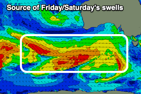
Swell wise, today's weaker energy will be followed up by swell with a bit more strength as the period draws out. This stronger swell was generated by the early stages of the frontal progression bringing yesterday's change and today's swell, and we should see good 3-4ft waves persisting tomorrow across the Surf Coast (inconsistent), with 5-6ft sets to the east.
Sunday should become smaller but still be 3ft on the sets across the Surf Coast in the morning and 4-5ft to the east, fading through the day, small into Monday.
Light, local offshore winds are due tomorrow morning (N/NW Surf Coast and E/NE-NE to the east), giving into moderate afternoon sea breezes from the E/SE-SE. Sunday will be best on the beaches with freshening N/NE-NE winds that will hold all day, stronger from the N/NE Monday morning, shifting NW into the afternoon.
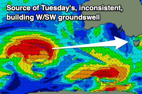
Now, moving into next week, we've got strong pulses of W/SW groundswell on the way, and the winds are now looking more favourable all round, though tricky at times.
The source of the swells will be a flurry of back to back frontal systems pushing up and under Western Australia, then through the Bight and onwards to us from today through next week (while weakening).
The first system will be the strongest but the most distant, with a great fetch of gale to near severe-gale W/SW winds currently projecting east through our medium-long-range swell window, south-west of Western Australia.
This storm will weaken on approach to Western Australia, leaving an inconsistent but moderate sized W/SW groundswell that's due to fill in Tuesday, building towards a peak into the afternoon.
The Surf Coast should build to an inconsistent 4ft on the magnets into the afternoon with 6ft+ sets to the east. Gusty W/NW tending W/SW winds are due on Tuesday as a mid-latitude front clips us, adding some additional mid-period swell into the mix through the afternoon, peaking through Wednesday. The earlier stages of this front will be moving up on the backside of the initial strong storm, pushing in through the Bight early next week.

This should provide surf more to 3-5ft across the Surf Coast Wednesday morning, easing through the day with continuing 6ft sets to the east.
Winds look to shift to the N'th Wednesday morning and strengthen ahead of the next mid-latitude frontal system, with a shift in winds to the NW and then W/NW on Thursday. Swell wise, this approaching frontal system looks generally average for swell production at this stage, with a drop in size likely from 3ft on the Surf Coast and 4-5ft to the east.
Longer term the outlook is less reliable but we'll have a closer look at this on Monday. Have a great weekend!
Comments
Thanks for forecast. When does that bells longboard comp finish, is last day tomorrow?
My pleasure. Yep.