Plenty of swell to come with favourable winds

Victorian Surf Forecast by Craig Brokensha (issued Friday 18th August)
Best Days: Tomorrow Surf Coast, Sunday Surf Coast, Monday, Tuesday morning, Wednesday, Thursday, Friday
Features of the Forecast (tl;dr)
- Mod-large mix of W/SW swells for tomorrow with gusty W/NW tending W-W/SW winds mid-late PM
- Easing swell Sun with mod-fresh W/NW winds, easing
- Moderate sized mid-period W/SW swells for Monday, strongest into the PM with fresh and gusty N/NW winds
- Persisting moderate sized W/SW swell Tue with gusty N/NW winds ahead of a late PM S/SW change
- Large mix of W/SW swells building Wed, strongest into the PM with a groundswell
- NW-W/NW tending variable winds Wed, fresh N Thu and locally offshore
Recap
Our inconsistent W/SW groundswell came in nicely yesterday, and a little better than I expected with fairly consistent 3ft+ waves on the Surf Coast, 4-6ft to the east along with strengthening N'ly winds.
This morning the swell is holding a similar size but with favourable winds for protected spots on the Surf Coast. A change has now hit creating poor conditions.

Solid and windy yesterday
This weekend and next week (Aug 19 - 25)
Today's change will be linked to a weakening low clipping the state, with its earlier stages through the week generating a healthy fetch of persistent gales towards us though over a generally small area.
We should see a moderate to large mix of mid-period and groundswell peaking through tomorrow, coming in at 4-5ft on the Surf Coast (rare 6ft'er on the magnets) and 6ft to likely 8ft to the east, easing back through Sunday from 4ft and 6ft respectively.
Winds will be favourable for the Surf Coast most of the day with gusty W/NW winds, shifting W-W/SW through the mid-late afternoon, fresh W/NW on Sunday morning, easing through the day.
Late in the day some new mid-period W/SW may be seen, though Monday is a better chance for this, followed by a stronger groundswell into the mid-late afternoon.
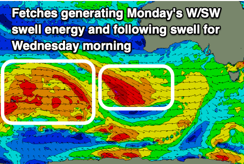
These swells will be generated by a flurry of frontal activity swinging in from the south-east Indian Ocean, in under the country today, through the weekend. Fetches of strong to gale-force W/NW winds should produce moderate sized levels of swell, coming in at 3-4ft on the Surf Coast Monday morning, likely a little more consistent in the upper range through the afternoon and holding Tuesday.
Moving into Wednesday, we should see a mix of slightly better mid-period W/SW swell ahead of a larger groundswell into the afternoon.
The mid-period energy will be generated by the broad, distant Southern Ocean frontal progression firing up behind the pre-frontal W/NW fetches, while the groundswell looks to be generated by a trialing low on the backside deepening rapidly, generating a fetch of severe-gale W-W/NW winds under Western Australia Monday.

What we're looking at is a mix of over-lapping swells that will build through Wednesday and possibly negatively interfere with each other creating close-spaced waves within sets.
Regardless of this, building surf to a strong 6ft is due on the Surf Coast through Wednesday with 8ft sets to the east, easing slowly Thursday from 4-6ft and 6ft to possibly 8ft to the east.
There's the chance of some decent sized reinforcing groundswell later in the week/next weekend but we'll review this on Monday.
Looking at the local winds and great N/NW breezes are due all of Monday, with similar winds due into Tuesday morning ahead of a trough and S/SW change later morning.
For the peak in swell on Wednesday, NW-W/NW winds are due through the morning, hopefully variable into the afternoon with N'ly tending local offshore winds Thursday as the swell eases. We'll confirm this and the timing and sizes of the swell Monday though. Have a great weekend!
Comments
Go on Craig, take a bow.
“Winds will be favourable for the surf coast all day most of the day..”
Like sex panther cologne, works 60% of time - all the time.
Haha whoops, I meant most of the day, and not all. Changed my mind ;p
nice reference mad titan
Classic :)
craigos like the milkman, just keeps delivery
This winter is relentless. It's gotten to the point where I almost look forward to an onshore day, just so I can have a rest day without feeling quilty for missing out. Ha
Keep it coming.
Is anyone else having problems logging into the VicPorts Port Phillip Heads swellbuoy?
I'm getting a security warning that the site is unsafe.
Has VicPorts been hacked?
Pain in the arse.
The Point Nepean wave buoy has been working ok for me adam12. The only thing is the graph showing the last 24 hours of readings is not there any more.
Yes it started working, but as you say without the graphs, when I tried it again later. I think it might be me that has been hacked, using a site I visit about 20 times daily. Bugger.
Same problem