Lower quality period of waves

Victorian Surf Forecast by Craig Brokensha (issued Friday 4th August)
Best Days: Today out of the wind, tomorrow and Sunday mornings keen surfers Surf Coast, Monday, Tuesday on the beaches, Wednesday on the beaches
Features of the Forecast (tl;dr)
- Moderate sized, close-range SW tending S/SW swell for tomorrow with W/NW tending SW winds on the Surf Coast
- Easing S/SW swell Sun with W/NW tending S/SW winds, freshening
- Late pulse of new, moderate sized, long-period SW groundswell Sun, peaking Mon AM, easing through the day and smaller Tue
- Variable tending S/SE winds Mon, N/NE tending E/NE Tue
- Inconsistent W/SW swell for later Tue, easing Wed with gusty N/NE winds
Recap
Good, easing 2-3ft waves with increasing winds through yesterday, best on the beaches to the east in the morning before becoming wind affected after lunch.
Today a tricky mix of new W/SW groundswell and better aligned SW energy are on the build with strong N'ly winds, coming in at 4ft to the east and 2-3ft on the Surf Coast. We'll likely see the Surf Coast reaching a more consistent 3ft through the day and 4-5ft to the east as winds shift more N/NW-NW through the mid-late afternoon.

Building, windy surf today
This weekend and next week (Aug 5 - 11)
Today's strengthening winds are linked to a strong mid-latitude low moving in from our west, with it currently too far north to generate any swell for us until it slips south-east this afternoon and evening.
As it does so, a fetch of strong to gale-force SW-S/SW winds will be generated in our close-range swell window, generating a kick in SW tending S/SW swell through tomorrow, easing back from the S/SW on Sunday.
The Surf Coast looks to build to the 4ft range tomorrow, easing back from 3ft+ on Sunday with 6ft sets to the east, easing back from 4-5ft Sunday.
Winds will be favourable and W/NW tomorrow morning on the Surf Coast but with lumpy conditions, with winds swinging SW into the afternoon.
Similar light W/NW winds are due Sunday morning before shifting S/SW into the afternoon and freshening.
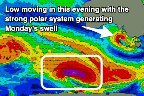
Later in the day we may see new sets linked to Monday morning's SW groundswell arriving, with it generated by a strong polar low that formed east of the Heard Island region yesterday.
The core wind speeds have been upgraded, with gale to severe-gale W-W/NW winds sitting right on the polar shelf (even a couple of storm-force barbs registered), though weakening into this afternoon while continuing to track east-southeast.
This will produce a moderate sized, long-period SW groundswell that should kick late Sunday but with the onshore winds, peaking Monday morning to 4ft on the Surf Coast (possible rare bigger one) and 6ft+ to the east, easing steadily through the day.
Winds on Monday look variable through the morning, likely tending locally offshore ahead of weak S/SE sea breezes, cleaner Tuesday on the exposed beaches with a light to moderate N/NE breeze, tending E/NE into the afternoon.

The swell will be smaller and easing back from 2ft on the Surf Coast and 3ft to possibly 4ft to the east.
Now, as touched on last update, the outlook for the rest of the week is slow with no significant swell generating storms expected to form close to the Australian continent. An inconsistent W/SW swell is due later Tuesday and Wednesday morning though generated in our far swell window and not likely topping 2ft on the Surf Coast and 4ft to the east. N/NE winds should favour exposed breaks with winds later week unknown thanks to divergence regarding a possible mid-latitude low moving in from the west.
A renewal of Southern Ocean fronts will hopefully be seen later week/next weekend but we'll review this Monday. Have a great weekend!
Comments
The worst thing about a great run of swell and offshores, is when it comes to an end.
Tell me about it!