Great run of moderate sized swell

Victorian Surf Forecast by Craig Brokensha (issued Monday 10th July)
Best Days: Surf Coast today and tomorrow, Wednesday, Thursday, Friday, Saturday morning
Features of the Forecast (tl;dr)
- Moderate sized mid-period W/SW swell peaking this afternoon with strong NW winds
- Reinforcing mid-period W/SW swell for tomorrow, peaking into the evening, easing Wed
- Moderate W/NW winds tomorrow, fresher N/NW Wed
- Inconsistent W/SW groundswell peaking Thu with strong N/NW winds, easing Fri with similar winds
- Small-mod sized mid-period W/SW swell building Fri PM
- Moderate sized W/SW swell peaking Sat with N/NW tending W/NW winds ahead of a shallow S change
- Easing surf Sun with lingering S winds
Recap
Windy, tiny surf for the most of Saturday with the big arvo tide claiming any increase in swell seen by dark on the Surf Coast.
The severe mid-latitude frontal progression linked to yesterday's pulse of close-range swell looked a bit stronger and better than forecast on Friday come Saturday, but alas the Surf Coast only saw surf in the 3-4ft range with the odd bigger one on the magnets.
Today winds have backed off and we've got better conditions with good 4ft waves on the reefs. Winds will remain offshore all day and a reinforcing mid-period swell should maintain similar sized surf all day.
This week and weekend (Jul 11 - 16)
West, west, west. That's no the Scottish boy band, just the outlook for the coming week or two.
We've got moderate pulses of mid-period and groundswell from the west due this week, strongest Thursday but inconsistent.
All this westerly activity will be thanks to a strong negative Southern Annular Mode event, lifting the westerly storm track up towards the mid-latitudes.

For the coming period, we'll see this activity focussed more towards Western Australia, rather than our region as was seen during June. This means strong mid-latitude fronts pushing in from the Indian Ocean, dipping east-southeast while weakening on approach to us, brining lots of westerly swell energy but more favourable, persistent winds from the north-western quadrant.
Following today's reinforcing mid-period W/SW swell, we've got a temporary drop tomorrow morning ahead of the next pulse of mid-period energy building through the day and peaking overnight, easing Wednesday.
This swell is being generated by a healthy mid-latitude frontal system tracking in under the country, generating a great fetch of pre-frontal W/NW winds on top an active sea state.
A kick back to 4ft on the Surf Coast magnets is due through the day, 6ft to the east, followed by an easing trend Wednesday from 3-4ft and 5-6ft respectively.
Winds will be good tomorrow and moderate from the W/NW all day, with Wednesday seeing fresher N/NW winds.
Moving into Thursday, we've got an inconsistent W/SW groundswell due to fill in, peaking through the day. This has and is still being generated by a great fetch of severe-gale W/NW winds following the frontal system generating tomorrow's building swell, and size wise it looks to be a little down on Friday's outlook.
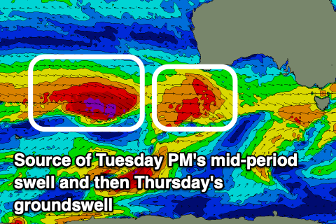
Due to the distance between the source and our state, there'll be a bit of swell decay. It'll be inconsistent but we should see the Surf Coast offering infrequent 3-4ft waves across the swell magnets at its peak (smaller elsewhere), with the rare 5ft'er likely (very inconsistent). The exposed breaks to the east should come in at a stronger 6ft with the rare 8ft cleanup.
Conditions will be windy but clean with strong N/NW breezes Thursday, persisting Friday as the groundswell eases and some new mid-period W/SW swell develops into the afternoon, peaking through the weekend.
Friday's building energy will be from multiple sources, generally off-axis strong W/NW fetches moving in ahead of a broader, Southern Ocean storm which will then produce a strong to gale-force fetch of W/SW winds on its north-western flank, in our western swell window.
All in all the size looks to be in the 4ft range across the Surf Coast Saturday and 6ft to the east under N/NW winds ahead of a trough and S'ly change into the afternoon, possibly lingering Sunday out of the S'th as the swell eases.
Longer term, the next round of frontal activity and swell looks to move in next week though the models diverge on the timing and intensities so check back Wednesday for an update.