Make the most of today, then focus on next weekend

Victorian Surf Forecast by Craig Brokensha (issued Monday 12th June)
Best Days: Today exposed beaches, Saturday, Sunday, Monday morning Surf Coast
Features of the Forecast (tl;dr)
- Fading swell tomorrow with strong N/NE winds, tending N/NW later and easing a touch
- Small acute W'ly swell Wed with strong W/NW winds
- Fading surf Thu with strong NW winds, N/NW Fri
- Moderate sized mix of W/SW groundswells building Sat with strong N winds, easing a touch Sun with gusty N/NW winds
Recap
There wasn't much of an increase in size seen through Friday afternoon/evening on the Surf Coast and the late, big high tide swallowed up the small slow swell, but Saturday provided much better surf with a mix of mid-period swell and inconsistent, building SW groundswell through the afternoon.
The waves were in the 4ft range on the Surf Coast magnets through the morning, building slowly to a stronger 5-6ft through the late afternoon on the magnets. Conditions were great all day with large surf to the east, best in protected spots.
Yesterday was excellent with all day favourable winds, glassing off late with inconsistent 5-6ft sets on the Surf Coast magnets, bigger to the east and with more options opening up.
This morning the swell is easing and winds are great for the beaches to make the most of the current surf.

A day for the beaches
This week and weekend (Jun 13 - 18)
Down, down, down.
Make the most of the easing swell today as the weekend's mix of swells will continue to bottom out over the coming days, with winds becoming less favourable and tricky for those exposed beaches.
Tomorrow will see strong N/NE winds, tending N/NW into the mid-late afternoon while easing a touch and with fading sets back from 1-2ft on the Surf Coast and 2ft+ to the east.
A small, inconsistent pulse of acute W'ly swell should maintain similar sized sets through the afternoon and Wednesday morning, generated by a high riding mid-latitude low that 's currently pushing through the Bight.
Gusty W/NW winds on Wednesday will unfortunately writing off the exposed beaches as the mid-latitude low pushes across us.
Thursday and Friday will be lay days as the swell eases along with strong NW winds on Thursday and strong N/NW winds on Friday.
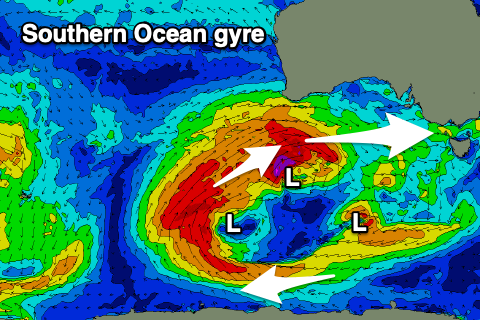
As touched on in last week's update, we've got some new W'ly swell due from the weekend and it will be quite a prolonged event thanks to a slow moving, southern ocean gyre setting up under the country.
This gyre will essentially be a large, broad area of low pressure with multiple low pressure centres spinning around inside it, producing multiple fetches of gales through our western swell window while moving slowly east.
This will produce multiple pulses of moderate sized W/SW groundswell, offering enough energy to provide a bit of size on the Surf Coast even with the westerly direction.
The first system will develop east of the Heard Island region this afternoon, projecting a fetch of gale to severe-gale W/SW winds east, generating an inconsistent W/SW groundswell for Saturday morning.
A better, larger secondary pulse of groundswell will quickly arrive through the day though, generated by a secondary, closer in proximity fetch of gale to severe-gale W'ly winds under Western Australia on Thursday. A third, slightly weaker and less favourably angled fetch will then soften the easing trend on Sunday/Monday.
Size wise, we should see the Surf Coast building to a good 4ft on the magnets into the afternoon, smaller and 3ft in the morning with the east due to build to 6ft+.
Sunday looks a little slower and more to 3ft to occasionally 4ft on the Surf Coast and 6ft to the east, then easing Monday.
Winds will be tricky on Saturday and strong from the N'th, easing a touch Sunday but holding out of the N/NW.
The backside of the gyre looks to bring W/NW tending SW winds on Monday with some small to moderate sized, mid-period swell due to follow. We'll have a closer look at this on Wednesday though.