Excellent Long Weekend of surf

Victorian Surf Forecast by Craig Brokensha (issued Friday June 9th)
Best Days: This afternoon Surf Coast, Saturday, Sunday, Monday exposed beaches, Tuesday morning exposed beaches early for the keen
Features of the Forecast (tl;dr)
- Moderate sized, mid-period W/SW swell peaking Sat AM, with a large, strong but inconsistent SW groundswell building into the PM
- Gusty N/NW-NW winds tomorrow
- Large, easing SW groundswell Sun with N/NW tending variable winds to the west, N/NW tending N/NE to the east
- Moderate sized, easing swell Mon with gusty N/NE winds
- Smaller Tue with strong N tending N/NW winds
- Small W'ly swell for Tue PM, holding Wed with strong W/NW winds
- Fading surf Thu with N/NW winds
Recap
The surf remained tiny across the Surf Coast yesterday with strengthening offshore winds, while a small pulse of westerly swell offered more consistent 2ft sets to the east with favourable conditions through the morning.
Today a weak mid-period W/SW swell is on the build, 2ft and clean this morning on the Surf Coast, with more size to 3ft+ due to develop through the day as winds hold out of the W/NW-NW.
This weekend and next week (Jun 10 - 16)
Today’s building W/SW swell energy is thanks to the remnants of a strong polar low (bringing tomorrow’s SW groundswell) weakening and racing through the Bight.
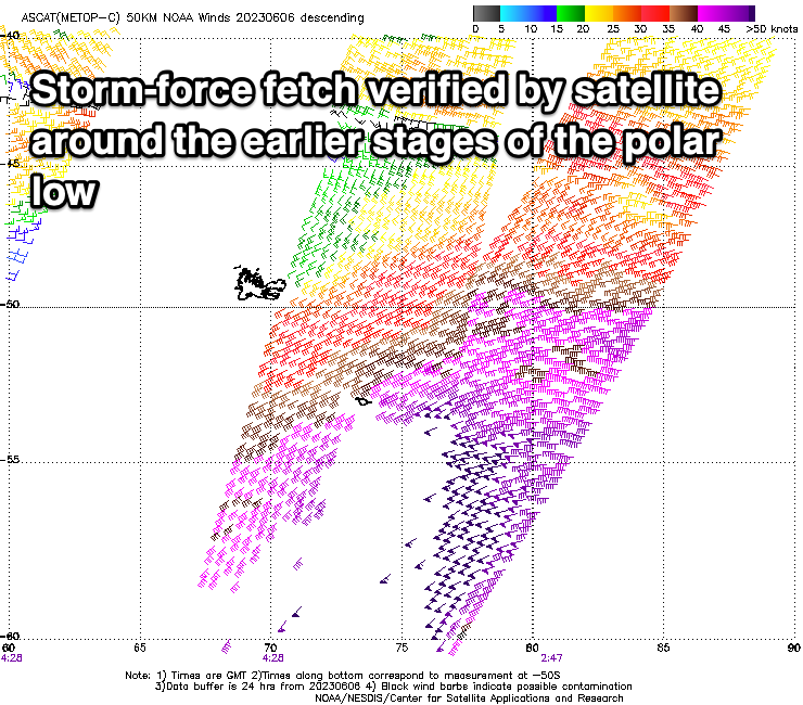
This saw a broad fetch of strong to gale-force W/SW winds projected through our western swell window, producing a moderate sized mid-period W/SW swell that’s building today and should peak tomorrow morning.
We should see the Surf Coast reaching 3ft+ this afternoon with 5-6ft sets to the east, with tomorrow morning coming in at 3-4ft and 6ft+ respectively.
Through the day though we’ll see a less consistent but strong SW groundswell signal arriving, building into the afternoon and peaking through the evening.
The source was the initial polar low with severe-gale to storm-force W’ly winds generated through our far swell window, still maintaining gale to severe-gale while projecting north-east towards Western Australia.
It’ll be inconsistent but we should see strong sets muscling up to 6ft on the Surf Coast magnets right on dark tomorrow with 8ft sets to the east, easing back from 5-6ft and 6-8ft respectively on Sunday. We can't rule out the odd bigger bomb pushing through at the peak of the swell though this looks to be under the cover of darkness.
Now compared to the recent weeks of swell, these sets will be much more inconsistent so keep that in mind and be patient.

Local winds look excellent for the Surf Coast and selected spots to the east with gusty N/NW-NW breezes due to persist all day, with Sunday seeing N/NW winds persisting all day on the Surf Coast, light into the afternoon and N/NW tending N/NE winds to the east.
Monday will see the swell tailing off more noticeably, easing back from 3ft to possibly 4ft on the Surf Coast, 4-5ft+ to the east and with fresh, gusty N/NE winds that will favour the exposed beaches.
Tuesday will become smaller and stronger N tending N/NW winds will limit options. Unfortunately following this, the rest of the week looks void of any major swell energy.
A mid-latitude low forming off the South West of Western Australia will generally be too far north and unfavourably positioned in our swell window to generate any decent swell.
Small pulses of acute W’ly swell are due from Tuesday afternoon and Wednesday, fading Thursday but with the low moving in and across us, strong W/NW winds on Wednesday won’t favour the exposed beaches and the Surf Coast looks small to tiny (possibly 1-2ft).
Winds will swing more N/NW on Thursday but the westerly swell will be fading.
Longer term a stronger frontal progression firing up towards Western Australia during early-mid next week, will stall to the west, producing a moderate sized, prolonged W/SW groundswell for next weekend with what looks to be winds from the western quadrant (NW Saturday and W Sunday). We’ll have a closer look at this on Monday though, have a great weekend!
Comments
Yippee! Nice work Craig.
beaut
Fancy that. After the last 3 years i feel like its a miracle to score good surf on a long weekend!
well said VIKO
It's nicely into the weekend arrival phase, sometimes it goes in sync with them
Winki has some nice lines today.
But wow I counted at least 50 on the cam earlier ...
Looks like the superbank. Shame this swell wasn’t 3 days earlier or later
13th looked pretty great early this morning with not that many out
13th is a hoax....A frame looks good but fattens out quickly and gets ruffled up by winds as soon as there's a hint of West in the wind.
You have to be taking the piss surely.
Otherwise, worst call in SN history hands down.
Spot on Stok , dont worry about 13th , just focus on the reefs boys .....
No point heading past Possos I say!
Some very good waves down the GOR but sets extremely inconsistent as Craig said it would be. Very crowded at times as well, which was to be expected.
agreed, further down the coast it was firing this morning
W.P. was pumping today :-) but it was no secret either. I have not seen so many people surfing down there despite the chilly water temperatures.
I don't usually go for a surf on weekends but the swell and favourable winds were too good to ignore.
Early this morning it was just glass with light winds, sunny and lines stacked to the horizon. What a beautiful stretch of coastline the Surf Coast is when everything comes together like today. It’s been rare in recent times but well worth the wait.
Today was phenomenal, best day of the entire run.
Some very nice waves today.
yep
I thought yesterday was better overall because the wind was NW all day. This morning down the road was a little bumpy early due to the wind being a bit NNE during the night. It took a while for the wind to groom it. This is me being fussy though.
Epic day. Dawn till dusk.
Awesome to hear crew!