Excellent weekend of surf

Victorian Surf Forecast by Craig Brokensha (issued Wednesday June 7th)
Best Days: Protected spots Friday afternoon, Saturday, Sunday, Monday, Tuesday exposed beaches
Features of the Forecast (tl;dr)
- Moderate sized mid-period W/SW swell developing Fri PM with strong W/NW-NW winds
- Mid-period W/SW swell peaking Sat AM, with a large, strong but inconsistent SW groundswell building into the PM
- Gusty NW winds Sat, possibly N/NW at times
- Large, easing SW groundswell Sun with N/NW tending variable winds to the west, N/NE into the PM to the east
- Moderate sized, easing swell Mon with freshening N tending N/NE winds
- Smaller Tue with stronger N/NE winds
Recap
The swell has slowly been fading the last couple of days but it is hanging in there at 1-1.5ft on the Surf Coast today and 2ft to the east. Expect the afternoon high tide to swallow it up.
This week and weekend (Jun 8 - 11)
Tomorrow will remain in the small to tiny size range ahead of a building mid-period W/SW swell on Friday that’s due to peak Saturday morning.
This will be the precursor to a much larger and stronger SW groundswell that’s due to build through Saturday afternoon, peaking into the evening.
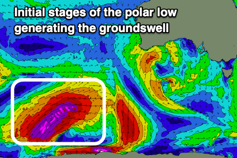
This whole swell evolution from west to south-west will be linked to the same storm, with it initially developing as a strong polar low in the Heard Island region.
The low generated a fetch of severe-gale to storm-force W’ly winds in our far swell window and is now projecting north-east while generating slightly weaker gale to severe-gales.

We’ll see the remnants of the low pushing east through the Bight as a frontal progression, weakening while moving across us on Friday and this will be the source of the mid-period W/SW swell energy, with the less consistent but stronger, larger groundswell due to follow.
So building sets to 3ft+ are due through Friday afternoon, smaller in the morning and more so 2ft to possibly 3ft, while Saturday morning should see 3-4ft waves on the Surf Coast. The Mornington Peninsula is expected to reach 5-6ft on Friday afternoon with 5-6ft+ waves on Saturday morning.
The less consistent but large, long-period SW groundswell is due to build through the afternoon, with a peak into the evening. While not ideal we should still see set reaching 6ft before dark on Saturday across the Surf Coast magnets, 8ft+ to the east, then easing back from 5-6ft and 6-8ft respectively Sunday morning. We can't rule out the odd bigger bomb pushing through at the peak of the swell though this looks to be under the cloak of darkness.
Locally winds look great with Friday see strong W/NW-NW winds holding all day. Saturday should provide persistent, fresh NW winds (possibly tending N/NW at times), while Sunday looks excellent with moderate N/NW winds to the west, easing into the afternoon, while tending N/NE to the east.
The swell will ease steadily through Sunday afternoon and Monday, backing off from 3-4ft on the Surf Coast magnets, 5-6ft to the east under fresh N/NE winds.
N/NE winds will persist on Tuesday as the swell reaches a low point, with the next pulse of swell looking to be small and west.
Longer term the outlook remains slower so make the most of the coming swell and winds.
Comments
Three cheers for El Niño…hippip ….